Showing posts with label Petchabun. Show all posts

Friday, January 3, 2014

Petchabun - Khao Kho 3

This time, I visited during the weekend before New Year and Khao Kho was buzzing with life as opposed to my most recent visit
.

The roads and sights were full of vehicles and people. Bangkokians love to go up north during the cold season to try on warm clothes of dubious quality and outrageous / cute design, such as hats with deer antlers. They wear these warm clothes (and gloves) even as temperatures during afternoons reach 25 degrees Celsius.
What is interesting to consider is that the area now almost devoid of trees, but filled with resort bungalows in cute colors, as recent as 1982 was a battle ground for clashes between the Thai military and communist insurgents.
Khao Kho Memorial
Over 2,000 died in the battles intermittently taking place over a period of 14 years. A memorial has been built. It is located at one of the highest, if not the highest, peak in Khao Kho. From roughly 1,150 meters above sea level, the views from the memorial ground are impressive.


Nearby, the Thai military has put a number of weapons used in the fight against communism on display. This is a great family destination – photo opportunities and opportunities for father-son bonding.
The main reason the communists were hiding out in Petchabun (as well as in a few other Thai provinces) was inaccessibility. The hilly area was back then heavily forested and without roads. The Thai military used communists-in-hiding as a great excuse for initiating massive logging operations in various parts of Thailand. Large proportion of the proceeds went into the pockets of well-placed generals. This was probably one reason for why the Thai military took over a decade to rout out relatively few communists. 
One tactic used in Khao Kho to get close to the communists was to re-engineer a Caterpillar and send it out in front to clear a path through the forest.

Today, there are not many trees in Khao Kho although a few national park areas remain. Bangkok people don't seem to care. They are there to say they've been in the mountains although 1,000 meters aren't much more than hills in my book. The area was a few years back marketed as "Little Switzerland", but the Harry Potter movies made New Zealand famous, so now Khao Kho is a place to go to breath "New Zealand Ozone" - Thais remain convinced that Ozone (rather than Oxygen) is good for you. 

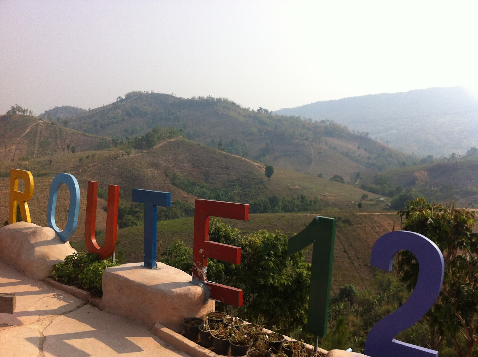
It is also a place to start a drive along Route 12 to see the "Ocean of Morning Mist". Route 12 is now being expanded from two to four lanes from Phitsanulok to Lomsak to accommodate the increased traffic.
Morning Mist But No Trees


Friday, January 25, 2013

Petchaburi - Panoen Thung


I visited the viewpoint before:


This time I noticed some warning signs that were way off the mark.
At least during the dry and hot seasons, the road is so good that there is absolutely no need for engaging 4WD, nor is there even on the steepest ascents a need to gear down to first gear. Most ascents can be done in third gear.
On the road to Panoen Thung as well as at the viewpoint, there are plenty of spots for bird watchers to frolic and butterfly enthusiasts can also find plenty of spots to enjoy their hobby. But getting to the viewpoint cannot be considered an off-road challenge.

This time, I went on the track that continues along the top of the ridge after having passed the viewpoint. However, after roughly seven kilometers, the park authorities had blocked the road, so I didn’t reach the waterfall. 

Wednesday, July 25, 2012

Petchabun - Thung Salaeng Luang National Park (2)

Let me repeat: The national park's headquarters is located at km. 80 on Highway No. 12. But cars are not allowed access to Thung Saleng Luang’s main savannah from the park headquarters. Cars have to enter the park at Nong Mae Na, i.e., from Khao Kho.
I repeat this because when checking both a couple of GPS as well as asking a few locals (or maybe not?) in Khao Kho, I was told to go to Highway 12. In other words, if I had not already visited this national park, I would not have found the correct entrance.

This visit was during the hot and dry season while my first visit was during the "cold" season:


http://tinamue.blogspot.com/2010/01/thung-salaeng-luang-national-park.html

It makes quite a difference. This time, the grass on the savannah was not as high (not as impressive) and park rangers had started several controlled fires in order to not risk that a bush fire ravages the park.

All in all, the dry season is not an interesting time to visit. Next time, I will try to make it during the rainy season as the tracks leading through the park then (hopefully) will be muddy, challenging and fun to drive.

Tuesday, July 17, 2012

Petchabun - Khao Kho (2)

 I earlier wrote about Khao Kho 


http://tinamue.blogspot.com/2011/02/petchabun-khao-kho.html 


This time, I visited during the week instead of during a long weekend. What a huge difference that made. There are many small family-run resorts in the Khao Kho area and there are many under construction or expansion. The main customers are Bangkokians coming up for a weekend. 
So, during weekdays, many of the resorts close down their facilities, e. g., it can be difficult to find a restaurant for a lunch meal and many restaurants shut down at 8 PM. Instead of taking that as a nuisance, I took it as an opportunity to go to bed early so that I could get up and see the sun rise over Khao Kho.
I again stopped by at the Route 12 rest area where the number of shops has increased slightly and where an old school bus has been brought in to give some American flavor.


Wednesday, July 11, 2012

Petchabun - Si Thep Historical Park (2)

I went back to Si Thep, but actually there isn't much new to add to my previous blog

http://tinamue.blogspot.com/2011/02/petchabun-si-thep-historical-park.html 

Si Thep is a nice destination for picnics and to learn a bit about how the tentacles of the Angkor kingdom spread across the region. What is interesting is that the ruins now are surrounded by a lot of sugar cane fields.
During the harvest season, the small roads leading to the few mills in the region are clogged. And around the mills, trucks (big and small) occupy huge parking lots where they wait for their turn to offload the sugar cane. To a casual observer, it definitely looks like a lot of time is wasted as the trucks wait for hours on end.

Tuesday, May 15, 2012

Petchaburi - Kaeng Krachan

As Kaeng Krachan is Thailand's largest national park (see my blog April last year) it has many attractions, including a reservoir that can be used for fishing and kayaking, a golf course, whitewater rafting, waterfalls, and bird watching.

The most famous destination for people with a craving for a bit of rough road is the Panoen Thung "mountain". For those wishing to drive up to the campsite at Panoen Thung, timing is important.
From Bang Krang campsite, the road is in poor condition and certain times are allotted for ascent and descent. Times for going up are 5.30-7.30 am and 1:00-3:00 pm. Times for going down are 9:00-10:00 am and 4:00-5:00 pm.   


Driving to / from Panoen Thung is best done in a vehicle with good ground clearance and a solid suspension, but the drive is not an off-road challenge as there obviously is a (gravel) road. A standard saloon car can do the drive, but only during the dry season.


During the rainy season, it can at times be challenging to find traction, but the road is anyway closed during the months where 4WD potentially would be needed. So, the park rangers deprive us for a good opportunity to test our 4WD trucks and SUVs.


Although it definitely possible to reach the top in a saloon car during the dry season, due care has to be exercised by the driver. Whilst crossing the streams past Bang Krang campsite, the entry and exit from the streams' floors can be quite steep - quite a number of visitors have ripped parts of their cars' bodywork off at these streams.

Tuesday, February 15, 2011

Petchabun - Thung Salaeng Luang National Park


The park is located both in Phitsanulok and in Petchabun provinces. It is a vast expanse of mountain ridges, ponds, grassland (or savanna), and forests. Streams zigzag through the pine and evergreen forests, and there are of course several caves and waterfalls in the ridges. The mountain peaks in the west of park are the tallest with some reaching 1,500 meters above sea level.

The area has an interesting history. It surveyed in 1959 in preparation for becoming a national park, but the area was closed to the public between 1968 and 1982 as the Royal Thai Army conducted operations against communist guerillas that were hiding in the area.

The park headquarters is located at km. 80 on Highway No. 12. Information on the park and accommodations can be obtained there, trekking / biking tours can start from there, and the peace of camping on the bank of Huai Khek can be enjoyed. Cars are no longer allowed access to Thung Saleng Luang’s main savannah from the park headquarters – i.e., from the north – they have to enter the park at Nong Mae Na.

All in all, there are 11 big and small savannas in the park spread along the left bank of the Huai Khek Yai River. The largest savanna (where the Nong Mae Na ranger station is located) covers around 10 square kilometers. By the end of the rainy season, the grass will often have grown as high as eye-level of a Thai soldier thus making hiding easy.

A purple flower (ngon nak) has adapted to the tall grass with impressively tall stems.

The evergreen forests shed their leaves to reduce evaporation during the dry season. Before the leaves are shedded, they turn yellow, orange, red, and brown thus giving the forest a wonderful “autumn look”.

In the southern part of the park, you’ll find Thung Nang Phaya, which probably is one of the largest pine forests in Thailand. It contains some very old and tall pine trees as well as a rare wild orchid (ueang chani), which nestles on the pine stems. The orchid’s stalk and leaves are covered with white “hair” and its flower is bright yellow.

A brochure for the park boasts that in the park there is 150 species of birds, 40 mammals, 200 amphibians, 200 kinds of reptiles, and an unknown number of butterflies.

Nature lovers can take advantage of the trekking and biking routes to enjoy the spectacular scenery. Best time to do so is probably between October and January whereas the worst time is probably June through September. The national park rents out tents and can also provide basic lodging to visitors.

Friday, February 11, 2011

Petchabun - Si Thep Historical Park


Surely, everybody has visited Lopburi's capital to take pictures of monkeys running around freely on the city's Khmer ruins. People may even, like me, have travelled to Lopburi to take pictures of blooming sunflower fields and visited the Pa Sak Cholasit dam and tried the train.
However, I think only few have thought of continuing north to visit Si Thep Historical Park, which is located in Petchabun, only a few dozen kilometers north of the Pa Sak Cholasit reservoir.

Si Thep is today's name of a Khmer town that – at the time – rivaled Phi Mai and Khao Phanom Rung in importance. Moreover, traces have been found of the area being populated as far back as 2,000 years ago, i.e., predating the Khmer settlement by more than 1,000 years.


The Si Thep Historical Park covers an area of almost 5 square km complete with remnants of walls and moats. Near the park are ruins of a tower and couple of Khmer monuments.


To be honest, what is left of the Khmer ruins is not all that impressive. Maybe that is one reason that - compared to famous Phi Mai and Phanom Rung - Si Thep does not have many visitors. It is thus possible to take leisurely strolls among the ruins and the ponds spread out across the park. At the same time, the service and the quality of the information offered from the park's officers are far better than at Phi Mai and Phanom Rung.


Saturday, February 5, 2011

Petchabun - Khao Kho


Khao Kho is made up of mountain ranges to northwest of Petchabun town about 1,200 meters above mean sea level. The area is being marketed as “Little Switzerland” and is thus competing with Wang Nam Khieo (in Nakhon Ratchasima) that is claiming to be “the Switzerland of Isan” when advertising in Thai media. 

I must hasten to add that when these areas are trying to market themselves as being Swiss, it is because of their natural beauty. They don’t want to be associated with the “Swiss village” Baan Jaarn (in Roi Et) that earned its moniker because around 20% of the village’s households have at least one Swiss son-in-law. The resulting influx of Swiss Francs has led to many design changes so many houses in the village now vaguely resemble Swiss houses. 

Sorry for the digression.

You certainly won’t find any snowcapped mountain peaks in Khao Kho, but by Thai standards, it gets very cold during November-February. Visitors from Bangkok can thus “rough it out” a bit at the many resorts in the area. Often, early risers can experience dense mist in the valley. So, if you stay on the ridges and peaks, it is like you are looking down on clouds.

Highway No. 12 (Phitsanulok - Lom Sak) is one of the main access routes. Along it, you can stop and enjoy the view at a coffee shop with tons of Americana trinkets.
Or you can stop a http://www.ilovekhaokho.com/ - a resort squarely aimed at young Bangkokians that come to “experience nature” including a children's zoo where even teenagers seem to enjoy playing with pet farm animals.

Personally, I certainly prefer Khao Kho to Wang Nam Khieo, but it is much further from Bangkok, so getting there requires more effort.