Showing posts with label road trip. Show all posts

Thursday, January 22, 2015

Laos - Road Trip

Last year, I took a drive from Ubon to Nakhon Panom on the Laotian side of the river. The crossing at Chong Mek was a bit hectic as I got caught up in focusing on getting the car's papers processed. It went so smoothly that I left the border crossing area and was about to start my journey when I realized I had forgotten to get myself a visa. So, I could actually have entered Laos without a visa.
Chong Mek Duty Free
Anyway, although it was surprisingly easy to get the car cleared, it did still take some time as I obviously was not the only vehicle crossing the border. All in all, it took around two hours including that I had to return and get myself a visa.
There is rain in them thar hills
A new road to Wat Phu has been built. It is a toll way costing 15,000 kip. The old (much more narrow) road still winds its way along the river, but the toll way is the best option. It runs closer to the hills where the clouds hang low in the rainy season.
Stairs to climb to reach Wat Phu
Navigating through Pakse to get on to the main road heading north was a bit tricky, but once that was done, it was clear sailing. The road is of decent quality, but it isn't wide and can be outright dangerous at night. It seemed every fifth vehicle or so did not have lights that were functioning. This can result in the unpleasant surprise of nearly plowing into the rear end of a slow moving truck. Likewise, many motorcyclists must have some sort of death wish as they were driving without lights.
Virgin Mary & Son outside Catholic church in Savannakhet
Savannakhet is a nice quaint town with several interesting old buildings and a bustling market. The promenade along the river bank was extremely under-utilized. I liked Vientiane 16-17 years ago when the river bank had a cluster of noodle shops and food stalls where one could have a meal and a cold beer or two. This was before the Vietnamese financed a major upgrade of Vientiane's roads and of the river bank. Maybe development will also catch up with Savannakhet one day. At least the visionaries of ASEAN want to link Mukdahan to the port of Da Nang via Savannakhet.
Green coffee beans
Continuing north to Thakhek brought me to the highland famous for its coffee and this was quite interesting. I did, however, not have much time to spend there. So, I returned across the bridge to Nakhon Panom. To cross back into Thailand went very fast. The bureaucracy was very light and took less than half an hour to clear.

Friday, July 4, 2014

Ubon Ratchathani - Pha Taem (Part 4)

Caveman Art
I visited Pha Taem before

http://tinamue.blogspot.com/2010/03/ubon-ratchathani-pha-taem-part-1.html

Back then, I did not think much about that the pre-historic rock paintings were done by cavemen 3-4,000 years ago. However, during my second visit, it hit me that 3-4,000 years ago is not that pre-historic. Ancient Greece was in fact quite developed at that time (the first Olympic games were held 776 BC). Although the exact time when Neanderthals became extinct is disputed, it is around 30,000 years ago rather than 3,000 years ago. Seen in that light, the cavemen art at Pha Taem became somewhat of a puzzle to me.
The View is Still Great
This time, I also ventured to Chanai Dai cliff. As was the case during my first visit, the trip turned out to be an adventure.

http://tinamue.blogspot.com/2010/03/ubon-ratchathani-pha-taem-part-2.html

This time, the adventure was weather induced. Roughly half-way across the dozen or so kilometers one has to drive off-road to get to the cliff, the gates of heaven opened and torrents of rain poured down. The off-road (across rocky surface) turns into a narrow track leading through a forest the last couple of kilometers before the ranger station. The rain water took the path of least resistance, which was that track. Driving, there was no way of knowing how deep the water was or whether parts of the track had been washed away.
Game Over - time to make a U-turn
However, with due care and 4WD, I made it to the ranger station. But then, it was game over. It was clear that although the rain had slowed down, the water flowed at ever higher speed. I made a U-turn before reaching the cliff to get out of the forest quickly rather than risk being stuck.


Friday, February 28, 2014

Thailand - Funny Signs

On road trips, one often encounter funny signs or signs one wonder why they were deemed necessary.
For example, in Ratchaburi, it is OK to bring your gun to a waterfall, but please don't shoot.

In Phattalung, deer are apparently not allowed to enter this forest.
 In Phang Nga, the local government provide a public swamp instead of a park for citizens and visitors.

In some instances, like below example from Cambodia, there is an issue with translation. The electricity factory referred to is actually a power plant.
Other examples from Cambodia are found in the creativity put into name giving of retail businesses and language schools. For example, 6-Eleven and K-Mart Burger are names of local mini-marts.

That reminded me of a burger chain in Kazakhstan that named itself King Burger and used colors & designs in its logo so that the similarity with Burger King was obvious. The burgers' taste was, however, pretty fatty and deplorable.

Sunday, December 29, 2013

Bangkok - Mother of All Traffic Jams

Many people complain every day about Bangkok traffic, but the real monster jams are experienced around New Year. Since I many years ago had the unfortunate experience of getting stuck around Cha Am (200 km south of Bangkok) in a slow-moving queue around of cars heading back from New Year vacation, I have tried to plan my trips to avoid a similar experience. 

However, last New Year, I had underestimated the spread of travel fever and increase in number of vehicles. On January 1st, I ran into a jog lam just north of Khon Kaen (450 km from Bangkok). This year, I planned better. Shortly after lunch yesterday, I was going in the opposite direction of the masses.

When I took the outer ring road at Phatum Thani, direction Bang Na, all lanes in the other direction were jam packed for a distance of around 40 km. Imagine sitting in that lane, starting your New Year vacation by being stuck at the ring road for hours. 
And then realize that this is only the beginning. The highway leading north was moving a snail’s pace all the way to just south of Petchabun (350 km north of Bangkok).

Sunday, September 15, 2013

Ratchaburi - Suan Pheung Update

Things move ahead in Suan Pheung district

http://tinamue.blogspot.com/2013/04/ratchaburi-suan-pheung.html

Since my last visit, they have got far along in the process of expanding the road connecting the provincial capital (Ratchaburi) with the discrict "capital" (Suan Pheung). The number of resorts, coffee shops, and fake sheep farms keep increasing. Note: the sheep are not fake, but the farming is - the sheep are there to allow Bangkokians to come in close contact with cute "nature".

When I visited, the hot spring was crowded with people from Bangkok, but Kaeng Som Maew was not. It seemed only locals were picnicking there and enjoying the rapids. However, there was some screaming when a snake decided to also take a swim in the midst of people enjoying themselves.
Kaeng Som Maew in rainy season
Another relatively undisturbed destination was a seemingly Hindu (or at least Indian) inspired temple. Instead of a Buddha statue, there was a large guy with an elephant's head.
A rather cute concept was that there were two over-sized rat statues ready to grant wishes. One had to whisper the request into one rat ear, while covering the other rat ear (to keep the wish a secret), and the rat would then consider granting the request.
Tell me your dreams

I must not have passed muster because I have not yet won in the lottery.


Monday, September 9, 2013

Ratchaburi - Khao Krajom (2)

In an earlier blog, I vowed to return to Ratchaburi and drive to the top of Khao Krajom during the rainy season.

http://tinamue.blogspot.com/2013/04/rachaburi-khao-krajom.html

As expected, what had been a walk in the park when the track was bone dry, had now become more challenging. Whereas use of 4WD was merely a recommendation during the dry season, it is a must during the rainy season. And yet, there were only two spots where one had to use the low range and had to be stubborn.

One was a stretch with deep ruts cut by rain water. The computerized traction control (limited slip differential) failed. Limited slip does obviously not mean no slip. Without manual differential locks, the wheel not touching the road spun and no power was transferred to the wheels touching the ground. It took several attempts to find a route up the ascent where the worst ruts were avoided and forward (upward) motion maintained.

The second problem was the very steep final stretch before the peak is reached. It took 3-4 attempts before I found a route where I could gain sufficient speed and traction to power my way up the hill. Again, without manual differential locks, I had to do the climb without finesse.

But I made it to the top.
Khao Krajom - View towards Burma

Saturday, April 20, 2013

Rachaburi - Khao Krajom


Khao Krajom as most road-signs say (or is it Khao Khrachom as some signs say?) is a mountain top near the border to Myanmar. It is located in Suan Pheung district in Ratchaburi. One the summit, there are camping sites, basic facilities, good views, and a quiet calm as one truly feels far away from the hustle and bustle of everyday life.
Map on sign near creek crossing
To reach the peak at over 1,000 meters above sea level is a challenge many Thai 4WD enthusiasts take on with gusto. During the dry season, it is not much of a challenge. However, the use of 4WD is recommended as one needs to secure grip on a “loose” surface.
Now track is dry and hard, but appears to be soft and slippery during rainy season.
The road from “civilization” to the peak is roughly 8 kilometers, which during the dry season can covered in around 30 minutes. During the rainy season, it takes 40-50 minutes. The first third of the 8 km is paved. During the dry season, the second half gets bumpy and dusty, but is not particularly challenging except for 2-3 spots that require a little bit “extra”.
River or rather creek to be crossed
One spot is a river crossing where people have to overcome mental blocks they may have that prevent them from driving through water. Water depth is unknown and potholes or obstacles can be hidden in the muddy water. I took the optimistic perspective that plenty of other vehicles had crossed before me. So, although alone in the wilderness at the time, I assumed that if those vehicles could cross, so could my vehicle.

To prove it could be done, I crossed back and forth six times. Despite water reaching ten inches up my doors, thus submerging my exhaust pipe in water for over a minute, the engine didn’t stall and no water entered the cabin. However, each time on the way back across the river, the tires would lose grip on the slippery pebbles on the river bed. Each time this happened, it sent some “what-if” thoughts racing through my mind.
The other trouble spots were some steep ascents – most notably the last 300 meters to the peak – where lose rocks and/or soft sand on top of a hard lateritic road surface made wheel spin inevitable. The only way to overcome this was to use the 4WD low range and climb slowly but methodically.
Top of Khao Krajom is within reach, but a final steep ascent awaits.
Except for these steep ascents, the rest of the road can easily be handled in 4WD high range by powering through in second gear and controlling wheel spins on sandy surfaces as / when they happen. Or one can make the journey at a more leisurely pace to potentially sight some wildlife – all I saw was some pheasant hens and a long dark grey snake crossing the road.

I look forward to trying to reach Khao Krajom during the rainy season where I expect the road surface will be slippery due to mud.

Sunday, January 6, 2013

Tak - Umphang

Umphang is at the end of the road. Well, not exactly, but after reaching Umphang, there really isn't anything but dead-end roads. Umphang should be a Mecca for nature lovers as there are many waterfalls, rivers, caves, and hot springs to explore. But Umphang's sights aren't easy to reach, one has to take a boat (raft) or trek for hours - or even days - in order to reach them. Umphang is for hard core nature enthusiasts.
Umphang is also difficult to reach. While the provincial capital (Tak) is on the main highway between Chiang Mai and Bangkok, Umphang is over four hours drive from Tak. The last 115 km takes around three hours as the road winds its way around and along the mountain ranges that divide Thailand and Myanmar. 

Umphang is copying Pai and Mae Hong Son by making the serpentine road's 1,219 curves a marketing tool by selling T-shorts and tacky souvenirs stating something along the lines of "I survived the 1,219 curves to reach Umphang". 

However, the people of Umphang should remember that Pai didn't become a hot destination for Bangkokians until after the 2009 movie "Pai in Love". So maybe Umphang should vie to be a location for a funny / romantic Thai movie? "Chua Fah Din Salai" (a movie from 2010, based on an almost 100-year old book) took place in Tak, but was a love story without a happy ending.

That was a detour. Fact is that 10 years ago, there was literally nothing in Pai. Now, it is so crowded during the cold season with tourists that drive there merely in order to be able to say "I survived the many curves to reach Pai" when returning to Bangkok. But not after having had a cup of coffee or two and taken 1,000 photos.  
Around Umphang, there are no towns - only villages. Many people are Karen, which is not surprising when one considers that Tak borders Karen State - one of the 14 states of the Republic of the Union of Myanmar. In Umphang, a tiny walking street is created on weekends with low-key entertainment, e. g., magician show for kids and a merry band of park rangers, that ends around 9 PM. 
In summary, Umphang is a great but hard-to-reach destination for nature lovers. 

Thursday, January 3, 2013

Tak - Getting to Thi Lo Su

Before going, I heard many warnings about the tough conditions and Thai web-boards are full of warnings that the road to Thi Lo Su can only be driven by a 4WD vehicle.

I heard and read similar warnings before going to Panoen Tung and they turned out to be way off the mark.

http://tinamue.blogspot.com/2012/05/petchaburi-kaeng-krachan.html

The same can be said about warnings about getting to Thi Lo Su.

The distance from the entrance to Umphang Wildlife Sanctuary to the ranger station near the waterfall is around 26 km. Only pick-up trucks and SUVs are allowed onto the road, but 4WD is not compulsory. 

The 26 km cannot be said to be much of an off road challenge. I did most of the first half of the track in second gear and most of the second half in third gear. The road is better than the road to / from Somsak Mine

http://tinamue.blogspot.com/2012/02/kanchanaburi-somsak-mining.html

I just recently saw a Nissan X-Trail going to Somsak and Pilok without any problems, and if such a "baby-SUV" can handle a road, then it is not that bad.

On the way to Thi Lo Su, I only engaged 4WD twice when having to drive across some muddy parts of the road. However, I think that having the right tires (All-Terrain) is more important than using 4WD. As the picture shows, having standard Highway-Terrain tires and 2WD can leave you stranded when climbing a muddy and thus slippery patch.  

After having helped the two hapless 2WD Toyotas out of their muddy mess, a 4WD Toyota with AT tires showed how not to do. Like the others, he put pedal to the metal, presumably to gain momentum going up hill. But this caused the wheels to spin, so he almost got stuck despite having all the correct "hardware". I went up the hill in second gear supplying a steady measure of torque to the wheels and avoided wheel spin.

At another soft spot, another 4WD Toyota with AT got into a mess by driving too fast. Mud can hide serious bumps and pot holes. He banged his engine block into the ground and got stuck when his front suddenly dived into a hidden hole.

So, while the park rangers are correct in not requiring visiting vehicles to have 4WD, I recommend visitors to consider their tire choice and to ensure that vehicles have extra ground clearance. Cars obviously sink down in mud and several places I could see normal pick-ups had sunk in so deep that their "under belly" had scraped along the ground. 

Thursday, August 30, 2012

Loei - Dan Sai

Just a quick note on the side. Take Route 2013 to Dan Sai if you enjoy driving on serpentine roads. I've done the tour three times including once during the middle of the night. That's exciting to drive through sharp turns at speeds where your tyres squeal like pigs when you cannot see what's beyond reach of your headlights. 

If you continue to Phu Ruea, there is a national park as well as good 4WD tracks. 

On the way to Phu Ruea, you pass Chateau de Loei, Thailand's first commercial winery. 

Sunday, March 11, 2012

Laos - Champasak (Si Phan Don)

The Khone Falls are the largest in Southeast Asia - the highest falls reach to 21 meters. These falls are the reason that the Mekong is not fully navigable from Viet Nam to China
Because of the falls, the French colonialists could not send gun boats and supplies by river from Saigon up to Vientiane and Luang Prabang. Likewise, they could not get agricultural products exported from Laos by using Mekong. So, they came up with the white elephant project of building a single-track railway between Don Det and Don Khon. It was a temporary railway from 1893, but became longer (seven kilometers in total). and stronger (i. e., permanent tracks, real locomotive) in 1897. 


The last train probably traveled the tracks in 1940 when Japanese troops took over from the French colonial masters. It was the first and only railway ever built, opened and operated in Laos until 2009. 
The area upstream from the falls is characterized by thousands of islands and countless waterways, giving the area its name Si Phan Don or '4,000 islands'. Half of these are submerged when the Mekong River is high at the end of a rainy season. The principal islands of Si Phan Don are Don Khong, Don Det, and Don Khon.   
Freshwater (Irrawaddy) dolphins can sometimes be seen near the southern tip of Don Khon looking towards Cambodia. 


From Don Khon, you can also see the Liphee Waterfall, which is very powerful at the end of the rainy season. Unfortunately, this picture is from my second visit, which was at the end of the dry season. 

Tuesday, March 6, 2012

Laos - Champasak (Vat Phou)

Champasak province can be reached from Thailand through the Chong Mek (Thailand) Vang Tao (Lao) border crossing. From Vang Tao, the road leads east towards the city of Pakxe, the province’s largest city. 

Champasak has a long history that begins with participation in the Funan and Chenla empires between the 1st and 9th century AD. Between the 10th and 13th century, Champasak became a part of the Angkor Empire. 

Following a gradual decline since the 15th century, it was enfolded into the Lan Xang kingdom but then broke away to become an independent kingdom. The short-lived Champasak kingdom had only three monarchs: Soi Sisamut (1713-37), Sainyakuman (1737-91) and finally Fai Na (1791-1811).

Vat Phou (Wat Phu if transliterated according to Thai rules) was a part of the Khmer (Angkor) empire in the early 10th century. At its height the temple and nearby city formed the most important economic and political center in the region.

The Vat Phou temple complex was designed as a worldly imitation of heaven and fitted into a larger plan that included a network of roads, cities, settlements and other temples across present-day Cambodia, Laos, and Thailand. 

Wat Phu is located on the slopes of the Phu Pasak mountain range and it is quite a climb (the steps are steep) to get up to the sanctuary. From up there, however, the view back down makes the climb well worth-while. 
The temple ruins now seen are the product of centuries of building, rebuilding, alteration and addition, with the most recent structures dating from the 11th century. Minor changes were made during the following two centuries, before the temple was converted to Theravada Buddhist use.
From the cliff wall, water flows from a natural spring some 60 meters to the left of the sanctuary. This water was once led into the temple to continuously bathe the Shiva-linga. Now, people pray to a Buddha statue. 

The spring water is said to have magic / healing properties and people come to carry it away by the bottle. I also dutifully filled a bottle, but it magically disappeared soon thereafter, so I cannot confirm the water's healing properties. 

Tuesday, February 21, 2012

Kanchanaburi - Off the beaten track (3)

In 2010, I visited the mines at Pilok and briefly mentioned it in a blog.


Last year, I visited Pilok and Somsak Mining Homestay and blogged about it recently. Here is a YouTube link that gives an idea of the drive down into the valley. 


Last year, before reaching Pilok, I stopped at Thong Pha Phum National Park to enjoy the views and to grab a cup of coffee before continuing. Just as we'd parked our cars, a big bird crash landed and started rummaging for food. 
A National Park officer came out and explained this bird had become so accustomed to people that it no longer was "shy" or scared of people. We even managed to hand-feed the bird some grapes before venturing on. 
The next stop before continuing to Somsak Mining (see previous blog) was Chokkadin (or Jokkadin) Waterfall. 

The road leading down to the waterfall has some steep declines / inclines and (especially during the rainy season) some deep ruts. If your vehicle slides into the deep tracks - as happened for my friend's pick-up - then even 4WD cannot ensure that you can get yourself unstuck without help. 

In our case, it required a lot of digging before the truck got out of trouble and back on the right track. 

We then continued and reached a grassy swampy area from where we walked to the waterfall. Other off-road people are so lazy that they continue driving on the river bed to reach the foot of the waterfall. This shows little respect for nature and can anyway not be recommended during the rainy season where the water level can be too high for a vehicle without snorkel to handle.

Saturday, February 11, 2012

Kanchanaburi - Somsak Mining

From Thong Pha Phun, off the main road from Kanchanaburi to Sanghklaburi, a narrow route, frequently blocked by landslides, twists through limestone mountains until it dead-ends at the Myanmar border.
Just before Pilok a sign indicates that there is 5.1 km to Somsak Mining Homestay, but warns that the road is rough and only suitable for 4WD vehicles. As usual, such claims are only partially true as there is sufficient traction in the dry season for a normal vehicle to handle the inclines and declines of the road. However, extra ground clearance is a must due to the rocky and pot-holed road, so while no sedan can possible handle the road, a 2WD Fortuner, Hilander or Prerunner should be able to get handle that road in the dry season.

In the rainy season, things can be a bit more challenging if/when rainwater erodes the surface of the already bumpy road.
At the end of the rough road, first time visitors are invariably amazed to discover a few small cottages suddenly popping up in a lush jungle valley. The homely resort is run by a smiling and welcoming farang “auntie”, Glennis, from Australia. She has quite a story to tell.
She met Somsak, a handsome young Thai studying at the school of mines in her hometown of Kalgoorlie. They got married and Glennis arrived in Thailand in 1966. Somsak went to run the tin mining concession that had been in his family’s hands for some 100 years. Pilok was back then a prosperous community. Cross-border trade flourished and the mines attracted workers from Myanmar.

Due to difficulties in accessing Pilok 40 years ago, Auntie Glen lived in Bangkok while Somsak came back to her and their son once a week. When the mining business faltered because of a sharp drop in the tin price, and Somsak got sick, Auntie Glen decided to move to Pilok. She fell in love with her new home in the jungle.
Somsak succumbed to cancer in 1994, a year after mining was halted at Pilok in wake of a worldwide slump in tin prices. Young people left to seek jobs elsewhere. Those who remain eke out a living among ramshackle buildings and forest huts.

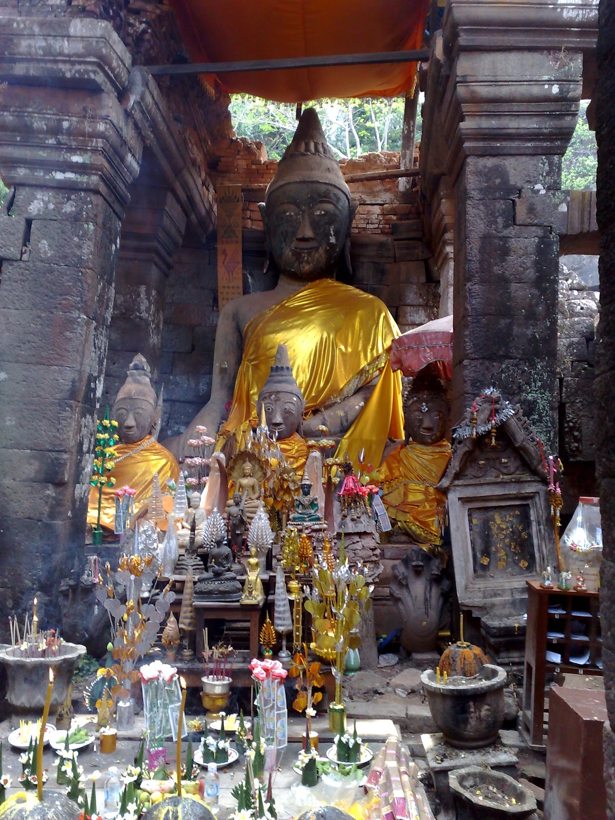
Some 240 of Somsak’s former employees remain in the area, among them five families working for Auntie Glen and a Myanmar Buddhist monk taking care of their spiritual needs. Here our 4x4 are parked just outside the tiny temple, which is reached by crossing a small bridge. 
The homely resort consists of two long bungalows in the forest and the converted warehouse for dining and lounging, all imbued with a tropical atmosphere mingling with ceramic bunny rabbits, pastel colored duck-lings, doilies and other Australian Victoriana. There are no telephones and electric power runs just five hours a day.
However, the combination of comfortable weather and a cozy home in the jungle attract travelers - particularly off-roaders. Various stickers on the door indicate just how popular the resort is with various off-road clubs.

Driving from Somsak back to the main road, to Pilok and onwards to Myanmar will reward you with some amazing views. From atop, you can see a small village nestled in the valley below, right on the Thailand-Burma border. Huge gas pipes and telecommunication towers can be easily seen among the small old houses.
That is Ban E-Thong and the pipes are part of the Petroleum Authority of Thailand's 260km pipeline carrying gas from Burma's Yadana field in the Andaman Sea to supply a 4,600 megawatt power plant in Ratchaburi.

Once Ban E-Thong and Pilok were bustling tin-mining towns. Thousands of miners, hundreds of merchants, shops, theatres and a casino kept this place busy around the clock. As they are only located around 50 km from the sea, many Burmese merchants back then came weekly to offer fresh seafood at very good prices.

Now, these towns are very quiet. All the miners have gone, but groups of tourist are now coming. Guesthouses and coffee houses thrive (except in the rainy season) and locals are getting into the tourism business as more and more people discover the joys of hiding away in these remote border towns.
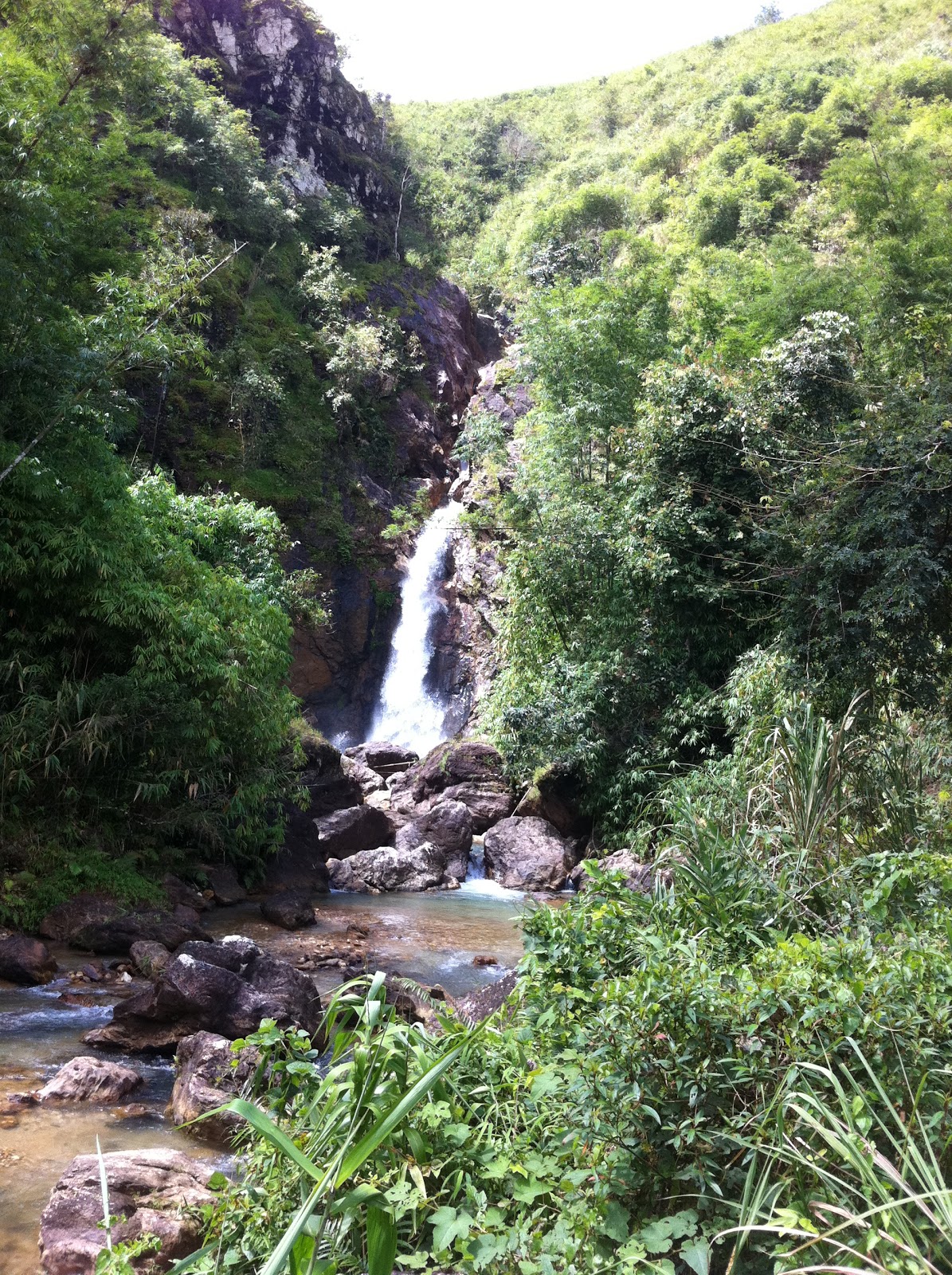
Thursday, February 2, 2012

Caravan

A phenomenon that has gained popularity in Bangkok is "caravan trips", i. e., group trips / tours by means of driving your own vehicle. At first, caravan trips were one or two days events to explore the areas near or around Bangkok. Since then, it has developed into trips lasting 5-15 days and going as far as to South Vietnam via Laos or to Southern China.
.
There are also caravans for special interests such as off-road driving and then you better prepare your car with snorkel, winch and A/T tires.

The increased interest in caravan trips was surely the inspiration for a very popular Thai movie from a few years back:

http://www.majorcineplex.com/movie_detail.php?mid=556


The movie is a romantic comedy where the background story is aa road trip through southern Vietnam (from Hue to Dalat) and the scenery is quite stunning. 

Monday, November 14, 2011

Kanchanaburi - Off the Beaten Track (Part 2)

Since my blog
http://tinamue.blogspot.com/2011/05/kanchanaburi-sangkhlaburi-4wd.html
that contained my opinion about Toyota Fortuner's (relatively) limited off-road capabilities, I have been asked to retract such "derogatory remarks".


So let me elaborate.
I have driven many SUVs and baby-SUVs and clearly vehicles with automatic gearshift and gasoline engines (such as Nissan X-trail and Honda CRV) fail miserably when facing real 4WD challenges like rocky or muddy mountain roads. The same can be said about a Toyota RAV4, but (at least with manual gearshift) it can be driven quite sportily, e.g., doing power slides through sharp turns on gravel roads. 

A Kia Sorento is also a 4WD vehicle, but it doesn't have the feel of a vehicle one would like to take off road. That being said, it's an awesome feeling to have a 3.5 liter gasoline engine rumbling under your foot. The 3.5 liter Mitsubishi Pajero has since 2008 strayed from being an off-road vehicle and is now a full option boulevard cruiser feeling under-powered compared to the Sorento.


Such baby-SUVs cannot hold a candle against rough-and-rumble vehicles like the Mercedes G-Wagon - it drives like a tank (heavy and unstoppable) but you can enjoy the ride in comfy leather seats - or the Toyota Landcruiser. Both, but especially the G-Wagon, are so superior off-road that they almost make such driving boring. 


(Let me add that I have a job situation that allows me to not worry about costs related to car ownership, maintenance, insurance or fuel consumption, and that has provided me with access to use a large number of different vehicles and drive in different countries over the years).


A Fortuner is not a baby-SUV, but a real SUV. That is, it is quite capable of handling relatively rough terrain while at the same time being quite comfortable on the hiway. Especially the version  powered by a 2.7 liter gasoline engine is a good drive on normal roads. Since that is where it's used most by most people, the lack of torque (compared to the 3.0 liter turbodiesel) for off road challenges is not that relevant. However, the increased fuel consumption probably is if one has to pay for what one consumes - something I fortunately don't have to, so I had great fun in the gasoline powered Fortuner also off road.
My points actually are:
* the Fortuner is an SUV, i.e., a multi-purpose vehicle rather than a dedicated off-road vehicle
* a Fortuner is mostly bought by people that use is on public roads, which is why the recently launched 2WD versions have been highly popular
* a Fortuner is a mechanically highly reliable vehicle; the model's initial flaw re weak brakes has been fixed but the suspension is still uncomfortable and far inferior to the Isuzu pick-up
* it is a good Thai product and at par with Toyota Prado models sold in the Middle East and superior to the Prado models sold in Africa.


So, my Fortuner loving friends can calm down. I support the notion that the Fortuner is a great all-round SUV. Join the club:

http://www.fortunerclub.com/main/index.php

Monday, August 1, 2011

Satun - Funny Road Signs


I want to show a couple of the funny road signs I came across in Satun.

One sign seems to forbid deer access to a forest. However, the text states that hunting / killing deer is not allowed.

Another sign states that there is an accident ahead. So, supposedly the "accident" has been there for a long time and nobody has any intention of removing the accident. It's better to simply warn people that the accident is there up ahead.

The sign is of course intended to be a warning of a high risk "black spot" where accidents occur frequently. In this case, it was a 90 degree turn, where apparently many motorists got surprised and instead continued straight off the road.


For a foreigner, one positive aspect of driving around Thailand is that many signs are in dual language - even signs that in my view are totally irrelevant for foreigners.

For example: "Weighing Station Ahead: All Trucks Must Stop" - I think there are very few foreigners cruising around Thailand in 10-wheel trucks.

Tuesday, May 10, 2011

Kanchanaburi - Sangkhlaburi 4WD


Many go there for the Three Pagoda Pass or for the Khao Laem Reservoir with its inundated temple. But Sangkhlaburi also offers some possibilities for great off-road driving. By that, I don’t mean ordinary dirt road driving, which most urban 4WD vehicles (like a Toyota Fortuner) can handle. By that, I mean rough tracks that are barely passable in the rainy season unless you have a modified 4WD and arrive with similarly equipped friends.
Most people having a 4WD vehicle never use the 4WD option or use it when it isn’t even necessary. In Kazakhstan, I saw what ordinary sedans could do on rough mountain roads as long as the driver was cautious. It is extremely rarely that I engage the 4WD when driving on dirt tracks, e.g., in Thai national parks. Unless the surface is slippery (mud, snow), 2WD will get you through most challenges – as long as your tires have grip, you normally won’t face problems as long as you have the necessary ground clearance.
In Sangkhlaburi, I hooked up with http://www.22nor4x4.com/2011/ to enter a national park. I soon got left behind. The Fortuner did not have the right tires, did not have sufficient ground clearance to leave me with a safety margin and with automatic gear shift it was difficult for me to control the torque.
Admittedly, it was during the rainy season, making conditions more muddy, more difficult, but I learned my lesson, admitted my defeat, and pulled out. Next time, I’ll use a proper 4WD vehicle.
A Fortuner is only suitable to cruise around Bangkok and to vist dry rice fields in Isan, but not for real off-road challenges