Tuesday, December 30, 2014

Chonburi - New Year at Wat Song Metta

When entering a new year, this is most often something people celebrate. However, many people take the opportunity to ponder the year that has passed and look ahead at what the new year may bring. Apart from the widespread tradition of making somewhat superficial resolutions for the new year, some people take a more serious approach. They choose to enter a new year while praying at a temple.
People are gathering
Wat Song Metta Wanaram is on a hill overlooking Ban Bang Saray (or Sa-Re) near Sattahip. New Year's Eve it will fill up with people chanting and praying for hours led by the monks of the temple.
Find yourself a place and a white cotton thread
If you are a believer, or maybe just want to try anything to secure some good fortune, then join us tomorrow evening. Or listen in on the internet radio broadcast.

http://www.watsongmetta.com/

Happy New Year

Saturday, December 20, 2014

Chonburi - Pattaya Sheep Farm

In Thailand, the trend of making cute animals available for town folks to pet probably started near Suan Pheung in Ratchaburi with the upscale Swiss Valley Hip Resort roughly 10 years ago. Since then, the concept was copied but simplified into petting zoos that catered to people's desire to snap cute photos.
Air craft and wind mill - where are the sheep?
Such venues are in Thailand often called "sheep farms" and at first they spread across Ratchaburi, then started to pop up in Khao Kho, and they are now found all across Thailand.
Sheep galore
There are two sheep farms near Pattaya - actually, in Bang Lamung and in Na Jomtien.

Car rental that I can afford, but I need somebody to push me.
The one in Bang Lamung is the biggest one and if you are young at heart, it can be quite fun to spend an hour there.You can pad and feed sheep, donkeys, ponies, pigs, ducks, geese, and chickens as well as take a boat load of cute photos. Much more fun than the cluster of fake European houses south of Pattaya:

http://tinamue.blogspot.com/2013/08/chonburi-mimosa-city-of-fakes.html

Thursday, December 11, 2014

Chonburi - Pattaya: City of Culture

Every year in December, Pattaya City sponsors a merit making ceremony early a Saturday morning. Last year, 2,600 monks were bused in. 
At his speech, and I am paraphrasing, the mayor of Pattaya said the ceremony was partly intended to show that Pattaya is not only a city of sin. However, I am pretty sure that this ceremony – starting at sunrise – escapes the attention of nearly all tourists and of the Thais engaged in the many shades of sinful activity that goes on all around Pattaya.
After the speeches, the monks circulated to allow worshipers to pay their respects and get their prayers answered. Considering that the Lord Buddha taught that the way to salvation is to free oneself from temptations and unholy matters such as money, it was an interesting aspect of the ceremony that 60% of the MC’s calls for prayer were for riches.

Saturday, November 22, 2014

Surat Thani - Koh Phangan

I had vowed not to return to Koh Phangan as the island surely would be different than when I first visited. That was back in the days before Full Moon Party was invented, when no road connect Had Rin to the rest of the island, when there was no electricity and no swimming pools. But I had a business appointment on the island, so I decided to combine it with some R&R.
Had Rin Nai
Had Rin Nai is still a very nice beach, but Had Rin Nok is not that great. And the area behind it is now packed with structures put up with no prior planning making roads and alleys a maze. Many structures are shoddy constructions intended to house party revelers in bunk beds. Delicious food is not to be had as bars and sellers of buckets (with alcohol of questionable origins) outnumber restaurants on Had Rin Nok. The service staff are mostly from Myanmar and have little training, which can result in interesting combinations being served. For example, I was given chopsticks as utensils for a plate of Italian pasta.

That being said, Koh Phangan has many beaches apart from Had Rin. A drive along the coast from Thong Sala to Ban Chalok Lam will take you past several nice bays, which I would prefer over Had Rin, but none of them can be said to be deserted. I went to see Ban Chalok Lam because when I first visited, that bay was used as a graveyard for fishing vessels. When fishing vessels were retired from service, they were pulled up on the beach and cannibalized for parts.
Thong Nai Pan Beach
Ban Thong Nai Pan used to be hard to reach, but the road has now been upgraded - when I first visited, it could only be reached on horseback.
They worked when we bought them - why check if they still work?
On the ferry back to the mainland, I noticed that safety concerns are not high on the list of the ferry company's priorities.

Friday, November 14, 2014

Surat Thani - Chaiya (2)

I already mentioned Wat Praborommathatchaiyaratchaworawiham in an earlier blog and this is definitely a destination worth going to again.

http://tinamue.blogspot.com/2011/10/surat-thani-chaiya.html

This time, however, I took the time to explore some hot springs in Chaiya. Only a few kilometers away from Wat Praborommathatchaiyaratchaworawiham -- down the small road that also passes the ruins of an ancient stupa --  is a small but steep hill with a couple of small caves. The hill is also the source of a hot spring. Since times as ancient as Wat Praborommathatchaiyaratchaworawiham, the hot spring was used to feed two pools. According to signs at the site, it was people of Indian origin who brought with the a tradition for hot baths as part of religious rites. The two caves also became "holy".
Hot but not enticing
Since these hot ponds turned out to be useless, I sought the advice from my GPS. It informed me that there were another hot spring relatively nearby. This hot spring -- about 4 km outside of town -- was much more difficult to find, partly because of a lack of signage, but primarily because my GPS indicated I should take a road that did not exist.
Hot mineral water
I eventually ventured along a gravel road that lead to a temple on the top of a hill. Just at the foot of the hill, a couple of ponds had been constructed from concrete. But, again, the area and the facilities appeared deserted and unused. The mineral water overflow from the concrete ponds discolored the rocks as it made its way down hill for form a small lake. The rocks looked to my untrained eye somewhat like lava, but was in Thai named Lan Lonk Prachan.


Wednesday, November 5, 2014

Chonburi - Pattaya Fireworks

Every year in November, Pattaya City arranges a fireworks competition stretching over two evenings where several nations vie for the honors. I have enjoyed the view both from the exclusivity (USD 100 tickets) of Hilton’s terrace bar and from a less luxurious beach chair (USD 1.50).
The view from up high at Hilton is far better than from shore side, but down at street level one meets more interesting aspects of real life. Last year, a Russian enjoyed the show together with a bottle of Thai whiskey. When the bottle was almost empty, he decided to go for a swim. Fully dressed and seriously drunk, he made it waist-high into the sea before he collapsed. Several good Samaritans rushed to pull the Russian back on the beach where he sat, drenched and smiling, for the rest of the show. 

Friday, October 17, 2014

Nakhon Ratchasima - Tublan Adventure

I went in search of Khao Phang Ma view point on edge of Tublan National Park in the hope of being able to see some gaurs (wild Indian bison or oxen) from afar.

The viewpoint (hill) was not easy to find. Directions on internet were contradictory and my two GPS gave two different locations. I opted for one of these locations. When I missed a turn, the GPS then immediately indicated a short-cut. This turned out to be the worst advice ever given.

The short-cut lead me to drive down a steep muddy descent (no way of getting back up that slippery slope), cross a creek, drive on an overgrown rarely used track, crawl between two small lakes, and then face a muddy incline. It looked easy, but I ended up sliding back down again and again and eventually got stuck. After numerous attempts of digging and piling stones into the ever deeper holes my tires dug, I went for help.

I encountered two national park rangers (apparently, at the steep decline was where I entered the national park), but after some pushing, they came to the same conclusion as me: truck dug in too deep.

Then they went to a nearby village and came back with a guy on a 4WD tractor. He pulled me (backwards) up from the hole, but in the mud, my pick-up started sliding to the left, down towards a small lake. He continued to pull me backwards but jerked to the right. The over-compensation resulted in the truck sliding directly into the bigger lake on the right of the narrow track.

From stuck, I was now REALLY stuck and partly under water.

His 4WD tractor could not pull me anywhere. He sent for a guy with a bigger tractor. 
Disaster has struck
However, rather than pulling me up, he almost ended up being stuck on the same hill where I had encountered problems. After much maneuvering, all his tractor did was making the mud even deeper and stickier.

The guys then sent for a manual winch. After some hard work, the truck got half way out of the water. They sent for another manual winch. The truck got almost out of the water.

Now, while all this is going on, it drizzles but increasing quantities of Thai whisky is being consumed so everybody is in a good mood. In fact, a couple of more guys (and a tractor) arrive to part take in the drinking and winching. People jump into and out of the lake in order to wash off the mud and there is almost a party mood while the dusk settles.

Around six hours have passed and there were now 6-8 villagers taking part in the rescue operation ("taking part" includes mostly drinking). Then a 4WD tractor finally pull the pick-up backwards and up from the lake.
Up it finally comes
Finally up on terra firma. I made a U turn. Winches and people were piled up in the back up my truck. Then, there was the issue that ... I could not go the same way back as I then would have to climb (in the dark) the steep muddy incline where I had first entered the national park.

So, after some palaver, the least drunk villager suggested to chain my truck to a tractor and pull me along a barely visible track through the national park. At one spot, I got stuck again. After several attempts, I got pulled up that hill by two tractors.

The worst was over. The last couple of kilometers, the track was still very muddy, but without inclines so I powered through and out.

Then it was time for dinner (and more whisky) with the rescuers who also received some cash hand outs for their time and efforts without which my truck would still be stuck in that lake.

Next day, I easily made it to the viewpoint without taking any shortcuts.

Friday, October 10, 2014

Nakhon Ratchasima - Khao Phaeng Ma

This hill, which apparently to some resembles the neck of a horse, is located in Wang Nam Khiao district between the borders of Prachinburi Province and Tublan National Park. The peak is 850 meters above sea level. The viewpoint is relatively easy to reach, only four kilometers from the main road. The last part is a rugged dirt road, but I saw several sedans make the trip.
Upon reaching the top, there are views towards Tublan. The Khao Phaeng Ma forest area is under the care of the Wildlife Foundation of Thailand. It covers an area of 16 square kilometers. Activities include trekking along an 1,800 meter track and animal watching.

The main attraction is to spot some of the few remaining wild gaurs. A gaur is a dark-coated bovine native to Southeast Asia and the Indian Subcontinent. It can grow bigger than the African buffalo and water buffalo. It is also in the context of Indian safari tourism called Indian bison.

In Thailand, the gaur is nearly extinct, but has found a safe haven in Tublan, especially in and near the Khao Phaeng Ma forest area. However, gaurs do on occasion venture outside their designated habitat as nearby corn fields provide tempting appetizers.

If you have patience, luck, and a telescopic lense, you can catch a glimpse of gaurs gathering around a salt lick. If not, you can pose with the gaur statue erected at the viewpoint.


Friday, September 26, 2014

Roi Et - Wat Pha Namthip Thep Prasit Varanam

Remembering names is not easy. I was in western Yasothon when somebody spoke highly about Wat Pha Namthip. This was supposedly an amazing temple, which I should not give a miss. So, I followed the directions given and soon crossed into Roi Et province where signs started mentioning Phra Maha Chedi Chai Mongkol.  It turned out that there are two names for the same temple. Locals use the name of the temple whereas visitors tend to use the more grand name for the chedi. 

And it turned out that I have been there before.


This time, repair and refurbishment work on the chedi was in process, so it was not easy to take pictures of the impressive interior without scaffolding or tools getting in the way.
From the outside, the pagoda is still impressive as well as huge (101 x 101 meters at the base and 101 meters high). To reach the uppermost room, one has to climb a narrow staircase, before one can pay one's respects as well as donate money to the on-going refurbishment work.

Friday, September 19, 2014

Nakhon Pathom - Buddhamonthon

The district is called phutthamonthon, but inside the park, the signs spells it Buddhamonthon. The park covers an area of 2,500 rai and was opened in 1957 to commemorate that it was 2,500 years since the birth of the Lord Buddha. 

After a long pause construction on the park resumed slowly in 1976 and the main Buddha statue was cast in 1981. The statue is almost 16 meters high and in a circle around the statue are sites representing the four main stages in the life of Lord Buddha: his birth, his Enlightenment, his first sermon, and his death.

The park also houses a museum and several ponds. People can relax under the shade of trees and enjoy the tranquility away from the hustle and noise of modern life.

In late 2011, the park was flooded for weeks on end. Almost USD 20 million were spent on draining the area and cleaning up the park 

Friday, September 5, 2014

Buengkarn - Phu Tok

I told the story about Phu Tok in an earlier blog.

http://tinamue.blogspot.com/2010/01/nong-khai-phu-tok.html
Phu Tok seen from the temple parking lot
I have now visited Wat Chetiya Khiri Vihan again. The rock cropping out in a otherwise flat landscape is still impressive and the network of staircases leading to the top seems only slightly less wobbly.
Gentle reminders at parking lot
In this blog, I will dedicate much more space to photos. The photos combined with the original blog should provide a full picture of the "Phu Tok experience".

It looks safe, doesn't it?
Making your way up is not intended to be easy. Wooden stairways encircle the rock and at certain locations, steep staircases lead to the next level. Except for the final stretch to the top level - this can only be reached by climbing up a path carved into the side of the rock.
7th level is up there - beware of the snakes !
But once the top has been reached, peace and tranquility will surround you. The top "floor" (7th level) is the top of the rock and it is all-natural - no ornate Buddha images or elaborate places of worship.
The path to the top level
The intention is that people shall ponder their values in life and realize that once this life ends, you cannot bring any material things with you to the next life. Moreover, once on top of the rock, it would be silly not to pause and take in the view.
View from the top - temple area and pond in foreground

Monday, August 25, 2014

Kanchanaburi - Srinakarin Reservoir

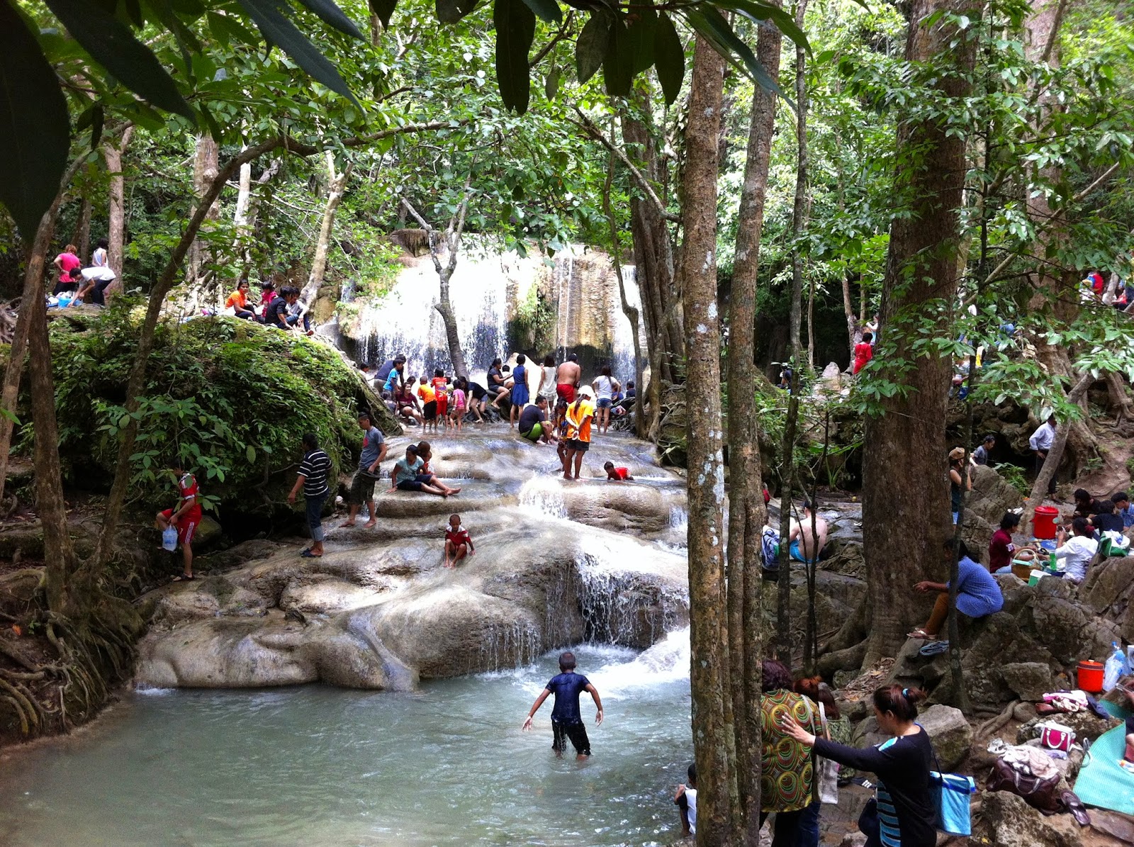
Even on rainy weekends, Kanchanburi is worth a visit. It has been years since my last visit to the 7-tiered Erawan waterfalls and they are now a very busy tourist destination. Locals and foreigners play around in the cool water or lounge on the shores of the stream.  The falls are beautiful, but the atmosphere is not quiet and serene. The sheer number of people makes it difficult to get a feeling of "being one with nature." 
Erawan Falls and plenty of visitors
 So, I decided to head to Huay Mae Khamin Wateralls. Again.


On the way, I stopped at Pra That Cave. It was is quite a climb to get to the cave entrance. The path was well laid out, but the jungle humidity during rainy season made the climb a sweaty one. 

At the cave entrance, a park ranger waited and gave a guided tour once at least four visitors had arrived. Inside the cave were the usual stalactites and stalagmites, but I was surprised by the size of the cave. It is made up of four big rooms and is much bigger than I had expected. 

Next on the agenda was the Huay Mae Khamin Waterfalls - the upper tiers could only be reached if you were willing to risk being totally covered in mud as the paths along the stream had turned extremely slippery due to rain. So, I decided to only enjoy the lower tiers and the view of the Sri Nakharin reservoir. 
Beautiful Huay Mae Khamin 
In fact, I decided to catch a ferry to Si Sawat across the reservoir. Getting from the waterfall to the ferry is bumpy and a bit risky for sedans during the rainy season. The ferries plying this route can best be described as minimalistic, but they do serve their purpose and the trip offers good views. 
Two Rainbows Don't Make a Crowd
As we were crossing, dark clouds came towards us and soon we were drenched. But then, the rain stopped as abrupt as it had started and two rainbows appeared.

Once on the other side, one can drive along the edge of the reservoir - a winding and scenic route - or take another ferry which cuts an hour off the travel time to reach Kanchanaburi city.


Friday, August 15, 2014

Uthai Thani - Cyber Waterfall

This waterfall has alternative spellings. I am not sure why "Cyber" seems to be the spelling most frequently used on the Net as it seems very "un-Thai" to me. At the park ranger station, there is a sign offering a much more correct transliteration.
You can call me Cyber
Anyway, the waterfall is located in the Huai Kha Khaeng wildlife sanctuary. One can park near the ranger station and must then trek roughly three kilometers in lush forest before reaching the waterfall.
Sai Bor is actually not an impressive waterfall, but it is a case of "it is not the destination, but the journey" as the trek provides views and sights that make it worthwhile.

More information can be found at:

http://www.huaikhakhaeng.net/

Sunday, August 10, 2014

Uthai Thani - Huai Khun Kaeo Reservoir

This reservoir in Huai Khot district is your typical run-of-the-mill reservoir. But on an island connected to the mainland by a causeway, there is a small spring that sprouts up to the surface: Ban Samo Thong Hot Spring. The water is clear (although with the aroma of sulfur) and has been put to good use.
The Royal Irrigation Department did some landscaping on the small island to create a rest area for visitors. Huts with mineral baths and a swimming pool with view of the reservoir are available for tourists.

Small bungalows can be rented for those who want quiet evenings / nights on the edge of a reservoir. I enjoyed my stay there and can recommend that you give it a try.
On your way to the Ban Samo Thong Hot Spring, you are likely to pass through Ban Rai. I did and I noticed some signs to caves and to an "old tree". I decided to take a look and as I got closer to the tree, the signs indicated different ages for the tree. I don't know which estimate is correct, but the tree is apparently between 250 and 400 years old.
Whatever the tree's real age is, it is impressive, but it is not worth a major detour to see the tree. Because once you get there, there is nothing else. You (and the tree) are in a small patch of forest surrounded by younger trees, and that's pretty much it.


Friday, August 8, 2014

Uthai Thani - Phathang Temple

This small village temple has an impressive Buddha statue located less than one kilometer of the main road.


On the way to the temple, you will pass the "ancient weaving cloth center" (an OTOP initiative) where you can buy over-priced hand-woven products.

Tuesday, August 5, 2014

Uthai Thani - Thung Yai Naresuan – Huai Kha Khaeng Wildlife Sanctuary

The Thung Yai Naresuan – Huai Kha Khaeng Wildlife Sanctuary was registered as a World Heritage Site by UNESCO in December 1991.

http://whc.unesco.org/en/list/591

It covers 5,775 square kilometers across three provinces: Uthai Thani, Kanchanaburi; and Tak. It is the largest connected conserved forest in Thailand and the South East Asia Region. To me, the important aspects of this national park is that it really is a sanctuary for wildlife (public access is more restricted than in normal national parks) and that it is so solely due to the work and sacrifice of one individual.

Visitors to the wildlife sanctuary are restricted to three relatively small areas. There are nature study routes (trekking) where one can enjoy flora and fauna. The national park area is so huge that one can only get to experience a tiny part of it. Today, it is a popular destination for groups of off-road enthusiasts who don't come to appreciate nature but to tear through the forest in their 4x4.

At the headquarters of the wildlife sanctuary, there is a statue of Seub Nakhasathien, the man who valiantly fought to preserve what remained of Thailand's forests. He was head of the sanctuary for eight months until he was overcome with despair over the obstacles he faced.

Seub Nakhasathien
 He is quoted as having said: "Personally, I'd rather do conservation research than focus entirely on trying to catch poachers and loggers. The people we catch in the forest are just the workers, not the masterminds. Those who are really responsible, the influential people who arrange and gain all the benefits from the illegal forest activity are never caught. The legal process doesn't apply to them."

For more info on this amazing person:  http://www.seub.or.th/

Near the headquarters, there is a memorial for the park rangers that have been killed while patrolling the wildlife sanctuary. Like khun Seub, these rangers paid the ultimate price in the fight against poaching and illegal logging.

Saturday, July 19, 2014

Nong Khai - Si Chiang Mai

Sala Keo Kou is at the provincial capital

http://tinamue.blogspot.com/2013/02/nongkhai-sala-keo-kou.html
Water is not falling
I went 80+ km to the west of Sala Keo Kou to explore a couple of waterfalls - Tan Tip & Tan Thong or Than Thip & Than Thong depending on how you transliterate their Thai names into English. However, since my visit was during the dry season, there was almost no water, so that was a waste of time.
Mekong at Hin Mak Peng
However, Si Chiang Mai is nearby - roughly 65 km to the west of Nong Khai city. The town is located on the banks of Mekong, just opposite Vientiane, the capital of Lao PDR. Its name is derived from Chiang Mai as the Lan Xiang king that founded Si Chiang Mai had a grandmother who was queen of Chiang Mai.
Vientiane at night
That origin of the name is rather irrelevant today, but the location gives for some great nighttime views across the river of Vientiane's lights. So, it is very nice to have dinner at one of the many basic restaurants along the river.
Chedi with the remains of Luangphu Thet
A once famous temple is located bit west of Si Chiang Mai. Wat Hin Mak Peng became the permanent base of Ajarn Thet Thetrangsi from 1977. Before that, he had been a "homeless monk" wandering through the rural areas of Thailand. At that time, Wat Hin Mak Peng was at a very remote location, but Luangphu Thet gained a large following as a master of meditation and teacher in the "forest tradition" (khammatthana) of Theravada Buddhism. He gained such a reputation that he on several occasions were visited by members of the Thai royal family, including by HRH King Bhumibol. Luangphu Thet died in 1994, but the temple is worth a visit. The temple grounds are large and with plenty of trees to provide shade and the temple area is adjacent to the Mekong River.
Wat Hin Mak Peng seen from the river
The Mekong River is in itself an attraction. Nong Khai being so far away from the sea, the river banks serve as beaches and locals also engage in fishing.
In the photo, the guys in blue and orange shirts are holding the two ends of a net they've dragged out into and along the river. They are now about to bring the ends together onshore to collect their catch.

Friday, July 11, 2014

Ubon Ratchathani - Sirindhorn Dam

Ubon is more than waterfalls, two-colored river, and caveman art. Ubon also has beaches. The most popular ones are along the banks of the reservoir formed behind the Sirindhorn Dam.
Ice cream anyone?
One grabs a space in one of the floating "houses" and settles down for some great food, a swim in the reservoir, and a tour on the banana boat. If you want, the ice cream man will bring you refreshments.

Friday, July 4, 2014

Ubon Ratchathani - Pha Taem (Part 4)

Caveman Art
I visited Pha Taem before

http://tinamue.blogspot.com/2010/03/ubon-ratchathani-pha-taem-part-1.html

Back then, I did not think much about that the pre-historic rock paintings were done by cavemen 3-4,000 years ago. However, during my second visit, it hit me that 3-4,000 years ago is not that pre-historic. Ancient Greece was in fact quite developed at that time (the first Olympic games were held 776 BC). Although the exact time when Neanderthals became extinct is disputed, it is around 30,000 years ago rather than 3,000 years ago. Seen in that light, the cavemen art at Pha Taem became somewhat of a puzzle to me.
The View is Still Great
This time, I also ventured to Chanai Dai cliff. As was the case during my first visit, the trip turned out to be an adventure.

http://tinamue.blogspot.com/2010/03/ubon-ratchathani-pha-taem-part-2.html

This time, the adventure was weather induced. Roughly half-way across the dozen or so kilometers one has to drive off-road to get to the cliff, the gates of heaven opened and torrents of rain poured down. The off-road (across rocky surface) turns into a narrow track leading through a forest the last couple of kilometers before the ranger station. The rain water took the path of least resistance, which was that track. Driving, there was no way of knowing how deep the water was or whether parts of the track had been washed away.
Game Over - time to make a U-turn
However, with due care and 4WD, I made it to the ranger station. But then, it was game over. It was clear that although the rain had slowed down, the water flowed at ever higher speed. I made a U-turn before reaching the cliff to get out of the forest quickly rather than risk being stuck.