On a total sidetrack, I came to think of the saga of the infamous Japanese Second World War treasure supposedly left behind in a cave in Kanchanaburi. Why anybody ever paid any attention to that story, I couldn't understand. Why the myth wasn't buried the first time around, is totally incredible.
In late 1995, Senator Chaovarin Latthasakiri (from Ratchaburi) was behind a drive to get the Thai government to fund a search for the treasure. The search went on for two months before it was abandoned. Not a single ounce was found out of the purportedly up to 6.000 tons of gold hidden by the Imperial Japanese Army.
In 1996, the Senator tried to increase the price of his Jaguar when he put it up for auction pretending to be selling a vehicle owned by His Majesty the King.
Not being a person that gives up easily, Chaovarin Latthasakiri (by then a former deputy Minister of Education) again in early 1999 tried to drum up interest in a government-sponsored treasure hunt, but his drumming fell for deaf ears.
However, in April 2001, Chaovarin Latthasakiri presented to the Thai press (copies of) old US government bonds as well as rumors of 2,500 tons of gold (plus a steam locomotive) hidden in the Liijia Cave. This created such a stir that then Prime Minister Thaksin Shinawatra flew to the cave's entrance to announce the government's backing of another treasure hunt.
Nobody wondered from where the Imperial Japanese Army would have gotten US government bonds and nobody questioned the denominations of the bonds. Each bond was valued between USD 50m and 100m - an incredibly large amount in the mid-1940s - i.e., in denominations that have never been used by the US Treasury.
Questions only arose after weeks of the Royal Thai Army searching turned up only dust.
Chaovarin Latthasakiri continued his political career as a avid supporter of Thaksin and is now a Member of Parliament for Phuea Thai Party.
Monday, December 24, 2012
Thursday, December 20, 2012
Samut Prakarn - Bang Kachao
The area in the map has been coined by many as “Bangkok’s Green Lung”. The area is actually namled Bang Krachao. In 1977, the government proposed to create a version of Singapore’s Sentosa Island. This was done by enforcing strict building regulations. .


There are lots of things to do on the peninsula, but don’t expect any chic hotels or finger nail spas. Among foreigners, one of the most famous activities is biking although no Bangkokian consider riding a bike a thing any sane person would do.
Small roads, narrow concrete tracks, and wooden paths meander through the greenery of Bang Krachao The majority of the tracks and paths have no railings and since they are elevated above the ground or a swamp so falling down would spell disaster.


Another niche activity is watching fireflies. Many tourists stay in one of the "home stay" houses along the banks. Prices range from USD 10-30 per night for riverside lodging, breakfast and dinner. The cheaper options are without not air-condition and revealing clothing, rowdiness, and loud noises are frowned upon.
Thursday, November 15, 2012
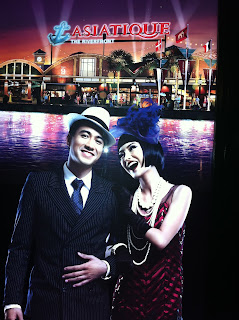
Bangkok - Asiatique
For just over six months, Bangkok has had a new "trendy" shopping destination, Asiatique the Riverfront. The plan is to develop it into the largest riverfront shopping venue in Asia. It is located on Charoen Krung Road and has a 300-meter stretch along the bank of the Chao Phraya River. The development probably has had an eye on similar venues in Shanghai.
At present, there is a total of 80,000 square meters, but the developer TCC Land (owned by the Beer Chang mogul) has big plans for the area, including two hotels and a fun/theme park.
100+ years ago, the river banks of Charoen Krung were Bangkok's main international port and this particular plot of land belonged to a Danish company called The East Asiatic Company Ltd.

TCC Land has tried to maintain the historic atmosphere of the site while turning it into a twenty-first century mall, a "festival market and living museum" concept. The idea behind the bazaar is to bring back the exotic mood of the old days by blending the old customs and history with modern-day recreation.
 It is of course mostly fake and the shops are aimed at tourists longing for useless trinkets at inflated prices. As the food options are not attractive to the local palate, young middle-class Bangkokians flock to Asiatique on weekends for the "cute" photo opportunities the place offers. Due to that there is only one access road, the traffic jams are horrendous.
For tourists, easiest way is probably taking a free shuttle boat from the Sheraton Pier near BTS Saphan Taksin. It starts running from about 5 p.m. There is also a Chao Phraya River Express that calls a pier at the temple next door.
At present, there is a total of 80,000 square meters, but the developer TCC Land (owned by the Beer Chang mogul) has big plans for the area, including two hotels and a fun/theme park.
100+ years ago, the river banks of Charoen Krung were Bangkok's main international port and this particular plot of land belonged to a Danish company called The East Asiatic Company Ltd.

TCC Land has tried to maintain the historic atmosphere of the site while turning it into a twenty-first century mall, a "festival market and living museum" concept. The idea behind the bazaar is to bring back the exotic mood of the old days by blending the old customs and history with modern-day recreation.

For tourists, easiest way is probably taking a free shuttle boat from the Sheraton Pier near BTS Saphan Taksin. It starts running from about 5 p.m. There is also a Chao Phraya River Express that calls a pier at the temple next door.
Sunday, November 11, 2012
Surat Thani - Khao Sok


My first visit ten years ago was the wettest -- and sleeping in a "house" built in a treetop on the bank of a stream did not make things less humid -- but included a great visit to a cave reached by boat (and a trek) from the Rachaprapah Dam. It was a U-shaped cave where the bottom end of the U was very narrow and one had to wade in cold chest-high water.

For Thais, Khao Sok is mostly famous for Rafflesia, which are the largest flowers in the world, and can grow up to 90cm in diameter. The flower is like a giant red bowl lined with yellow spotted petals. The flowers exude a strong smell – similar to the smell you would expect to find near a rotten carcass or a dustbin - but does fortunately not flower for long.
Saturday, November 3, 2012
Prachuab Khiri Khan - Hua Hin Floating Markets
Two retrostyle attractions of the "floating market" type opened last year near Hua Hin as if this country needs more fake history and more shopping venues. In Hua Hin, the new markets are miles from the nearest river, but that does not seem to detract from their attraction of being places to take "cute" snapshots and buy tacky souvenirs.
 That these markets were opened only a few kilometers from each other is a bit of a mystery from a competition perspective, but the explanation must be that they are located where land was available. The floating markets are located in a rural area on what used to be pineapple fields. The pineapple fields surrounding the markets are still dry reminders of how fake the floating markets are.


Saturday, October 20, 2012
Nakhon Ratchasima - Dan Kwian Pottery Village
One of my first trips outside Bangkok was to Suranaree Technical University's campus (back then, the university was still under construction). On the way back, I was shown around Dan Kwian to see how Thai pottery was done. Back then, the products were mostly for practical purposes, such as collecting rain water.
How things have changed. Dan Kwian has embraced the mass market and now the pottery made is mostly for decorative use. Sure, these farang kids pictured below are cute, and the clay figures probably sell well, but they don't have much to do with Thai culture or with traditional handicraft skills.

How things have changed. Dan Kwian has embraced the mass market and now the pottery made is mostly for decorative use. Sure, these farang kids pictured below are cute, and the clay figures probably sell well, but they don't have much to do with Thai culture or with traditional handicraft skills.

Wednesday, October 10, 2012
Satun - Koh Lipe

Koh Lipe is home to some six hundred Chao Lei people who are descended from 'sea gypsies' that have lived on the Andaman coast for centuries. Masters of the sea, the Chao Lei settled on Koh Lipe when the King of Thailand offered them citizenship and land in return for settling the island, and thus at the time helping to fix Thailand's southern sea border with Malaysia.

Not so reliant on the sea as they once were, the local community is adapting to the changes tourism are bringing.This development includes dive schools, an increasing number of resorts, and a tacky "walking street" (named after an infamous stretch in South Pattaya).


Friday, October 5, 2012
Thailand - Off the Deep End


Thursday, September 20, 2012
Buriram - OTOP
Buriram has a little known „One Tambon, One Product“ (OTOP) enterprise: a Cowboy Hat Factory.
Who came up with the idea that a tambon should specialize in making cowboy hats, I don’t know, but it is clear that the owner of a restaurant next to the cowboy hat outlet is a huge fan of Carabao. The rustic restaurant is full of pictures from the band’s early years (i.e., late 1970s). There also pictures of the student demonstrations that the Thai military crushed with indiscriminate violence resulting in a swelling in the ranks for the Thai Communist Party.
Carabao was actually formed in the Philippines (hence the name, carabao, which means buffalo in tagalog), but the band - and its frequently changing members - has aged since then. And as the band went more main-stream, the corporate sponsorship deals (primarily beer and energy drink) have greatly enriched the most famous band members.
12 years ago, I often met Aed and other band members as they were (and still are) members of a Harley Davidson club. They often participated in the club’s social activities on weekends.
Since I’m already digressing, let me point out that Thailand’s vastly popular OTOP scheme was copied and implemented in Cambodia a few years back. It’s been copied so diligently that the main products offered for sale are basically the same as in Thailand. However, I guess as long as the sales efforts aren’t focused on export markets (but sales only take place from village shops) then there is no direct competition.

Tuesday, September 11, 2012
Ranong - Khao Fachi Village
Before 1942, the village of Khao Fachi was where the La-un community is now located. The banks of the La-un canal were rich with mangrove forest and the Royal Highway Petchkasem no. 4 ended at the La-un canal. There was no bridge to cross the canal and Ranong City had to be reached by boat.
On December 8th 1941, the Japanese army landed at Pak Nam Chumpon. The Japanese moved quickly and had captured Victoria Point in Burma by the end of December 1941. Because of the difficult terrain, with narrow and steep winding paths, it was not easy to move troops and supplies and heavy weapons could not be transported along this route. Therefore, the idea of constructing a railway parallel to highway no. 4 was hatched.
After landing at Chumpon the Japanese forces looked for a suitable place to set up their headquarters. They established Khao Fachi village (the present Bang Kaeo community) as their military headquarters. This became an important base of a number of bases set up along the Andaman coast. The position was important because troops and supplies could be moved by land, sea and air to strengthen their hold on the region.
The headquarters was established at the top of a hill, at a height of 259 metres. This gave the soldiers a commanding view over the surrounding countryside and from here they were able to observe enemy movements on land, sea and air. The Kraburi, River the La-un canal and the Kema Yai and Maliwan canals in Burma could all be seen from this vantage point.
Anti aircraft guns were situated around the garrison and were used when allied aircraft from Burma bombed and attacked the base with machine guns. For protection the Japanese surrounded the base with air raid shelters and trenches. Camouflaged accommodation for the commissioned and non-commissioned officers was situated in the valley. The camp also had its own water storage systemand a well. The soldier’s quarters were at the foot of the hill.
The complex also included a hospital, kitchens and dining halls, and a railway station. This railway station was the most southern of the military stations. The double railway track allowed the wood-fuelled steam locomotives to make a U-turn and return north.
The complex also included a hospital, kitchens and dining halls, and a railway station. This railway station was the most southern of the military stations. The double railway track allowed the wood-fuelled steam locomotives to make a U-turn and return north.
Surveying of the railway route began on May 16th 1943. The line ran parallel to the Chumpon-Kra Buri highway to the La-un canal some 90 km away. On May 31 1943 an agreement was signed, between the Thai Supreme Commander and the Commander of the Japanese Army, for the construction of a railway across the Kra Isthmus.
The shortage of labor was a major problem because the majority of Thai villagers were employed in other areas of the war. No heavy earth moving equipment was available and the excavation relied heavily upon manual labor provided by Malaysian and Chinese workers. Thai carpenters were used for the construction of the wooden bridges.
Work on the railway commenced in June 1943 and the rails had been laid by November 1943. Prisoners of war and laborers were brought by train from Chumpon Railway Station. They were then marched a long distance to the construction sites. Many of these workers died from disease. Some of the prisoners escaped to Petchaburi and survived by begging for food from villagers on the way. Prisoners that were recaptured by the Japanese were treated very harshly and returned to prison.
Work on the railway commenced in June 1943 and the rails had been laid by November 1943. Prisoners of war and laborers were brought by train from Chumpon Railway Station. They were then marched a long distance to the construction sites. Many of these workers died from disease. Some of the prisoners escaped to Petchaburi and survived by begging for food from villagers on the way. Prisoners that were recaptured by the Japanese were treated very harshly and returned to prison.
Railway sleepers and bridges were made from wood and in total 31 bridges were constructed along the route. The track gauge was 56.5 inches, the same as in Malaysia. The rails themselves were brought from Kalantan in Malasia and were transported to the construction sites on freight wagons. The radius of the curves varied between 400 and 1,000 metres. On the entire route there were 137 curves, and 8 cuttings were driven through the landscape. The railway began south of Chumpon and along the length of the railway were six more stations before the tracks ended at Khao Fachi.
On reaching Khao Fachi the goods were unloaded and transferred to boats for further transport along the La-un canal to the River Kra Buri and hence on to Victoria Point. The Japanese used the railway for just 11 months. Heavy use of the track ceased when, on March 19th 1945, heavy allied bombers attacked the railway and the base at Khao Fachi. Severe damage was caused, destroying part of the track, and sinking boats and supply ships on the La-un canal.
In June 1945, the Japanese dismantled a part of the track, between 28 and 30 km from Khao Fachi quay. The sections were used to repair the damaged track further south. Attempts were made to keep the railway open, but further allied air attacks meant that it could no longer be used for transporting heavy weapons. Only food and light equipment could be moved along it to the soldiers at Victoria Point.
The Japanese surrendered on 10th August 1945 and their army was disarmed. British soldiers dismantled the railway and the rails were returned to Kalantan, Malasia.

Now, the remains of guns, ammunition, mortar bombs, as well as of the tunnels, trenches and underground shelters are hidden evidence bearing testimony to the existence of the WWII Military Base. As for the railway, there are overgrown paths, rusty tracks, decaying sleepers, and sadly, the remains of those who died.
Sunday, September 9, 2012
Lopburi
 Although once an important city, Lopburi rarely appears on tourist itineraries. Most visitors to the city are Thais on a day trip from Bangkok to see the historic sights (mostly temple ruins like Phra Prang Sam Yot) and / or take photos of the sun flower fields encountered enroute to the city.
 Phra Prang Sam Yot is probably Lopburi's most obvious landmark as is situated smack in the middle of the old city. This temple is quite a sight with its three "prangs" dominating the town center and army of monkeys roaming around the ruins and in streets nearby.
During the Dvaravati period (6th to 11th century), the city was called Lavo and the Khmer built many impressive temples. Lopburi later liberated itself from Khmer rule and had by the 1300s become associated with the Thai kingdom Sukhothai.
In 1665 King Narai the Great (of Ayutthaya) ordered the construction of a the new palace on the east bank of the Lopburi River and made Lopburi the second capital of the country in middle of the 17th century.
Thursday, August 30, 2012
Loei - Dan Sai
Just a quick note on the side. Take Route 2013 to Dan Sai if you enjoy driving on serpentine roads. I've done the tour three times including once during the middle of the night. That's exciting to drive through sharp turns at speeds where your tyres squeal like pigs when you cannot see what's beyond reach of your headlights.
If you continue to Phu Ruea, there is a national park as well as good 4WD tracks.
On the way to Phu Ruea, you pass Chateau de Loei, Thailand's first commercial winery.
If you continue to Phu Ruea, there is a national park as well as good 4WD tracks.
On the way to Phu Ruea, you pass Chateau de Loei, Thailand's first commercial winery.
Monday, August 27, 2012
Loei - Phi Ta Khon
Every year in June or July (the date is not fixed), the town of Dan Sai hosts the Phi Ta Khon (or Pee Ta Khon) festival. This year, the festival fell on a weekend so the number of visitors topped 60,000 - hotels as far away a Loei City (80 km away) were fully booked as the festival had been promoted even on CNN.
The ceremony usually starts as early as 3 AM with a parade of men from Phon Chai Temple in Dan Sai district to the Man River. Before sunrise, they perform a rite to invite Phra Up Pa Khut, which is considered to be a white marble representation of a holy monk having supernatural powers that can change his form to be whatever he likes to be. The procession will then bring Phra Up Pa Khut back to the temple where the sacred worship will begin.
 The colourful activities begin on the second day at dawn with local people dressed as Phi Ta Khon. They cheerfully perform and dance around the village in the afternoon. Beautifully decorated cars make up the street parade adorned by colourful flowers and candles. Late on the second day, bamboo rockets will be launched into the sky to encourage rain clouds to soak the fields prior to rice planting.
Phi Ta Khon is one half of a festival known as 'Bun Pha Ves.' The other half is the Bun Bang Fai, a festival held to "celebrate" fertility -- the Phi Ta Khon dancers cheerfully wave giant wooden phalluses around and the rockets are also potent symbols of male virility.
The ceremony usually starts as early as 3 AM with a parade of men from Phon Chai Temple in Dan Sai district to the Man River. Before sunrise, they perform a rite to invite Phra Up Pa Khut, which is considered to be a white marble representation of a holy monk having supernatural powers that can change his form to be whatever he likes to be. The procession will then bring Phra Up Pa Khut back to the temple where the sacred worship will begin.

Phi Ta Khon is one half of a festival known as 'Bun Pha Ves.' The other half is the Bun Bang Fai, a festival held to "celebrate" fertility -- the Phi Ta Khon dancers cheerfully wave giant wooden phalluses around and the rockets are also potent symbols of male virility.
Sunday, August 19, 2012
Loei - Chiang Khan


Personally, I prefer to stay a bit further down the river. The Mekong at Chiang Khan is quite wide and do not seem to flow anywhere. A few kilometers downriver, however, the Mekong breaks up into pools of still water during the dry season, while it flows at a rapid pace in a narrow canal close to the Laotian side.

Sunday, August 12, 2012
Phitsanulok - Phu Hin Rong Kla National Park (2)
As I wrote, to approach this national park from the east (i.e., from Lomsak) is the best option by far if you like to drive up serpentine roads enjoying wonderful views.
http://tinamue.blogspot.com/2010/01/phu-hin-rong-kla-national-park.html
 This time, I started at the other end of the park and therefore had to drive down the serpentine road. Such a descent has never before been a challenge. However, this time, I was not only driving a car with automatic gearshift (next to no engine brake) but I was also driving a Toyota Fortuner - a vehicle notorious for its weak brakes. 2/3 down, the brakes had gotten so warm that they stopped working. I pulled over, swearing, and missing my sturdy D-Max with manual gearshift.
Not being an overly patient driver, I soon decided to ignore that minor issue and continued rolling down in the lowest gear possible.

http://tinamue.blogspot.com/2010/01/phu-hin-rong-kla-national-park.html

Not being an overly patient driver, I soon decided to ignore that minor issue and continued rolling down in the lowest gear possible.

Wednesday, August 8, 2012
Loei - Suan Hin Pha Ngam (2)

http://tinamue.blogspot.com/2010/12/loei-suan-hin-pha-ngam.html

Moreover, a guide also caught up with me, but after seeing that I knew my way along the trail and verified that I'd been there before, she didn't provide an explanation of any kind to any of the things we encountered on the trail.


Wednesday, July 25, 2012
Petchabun - Thung Salaeng Luang National Park (2)


This visit was during the hot and dry season while my first visit was during the "cold" season:
http://tinamue.blogspot.com/2010/01/thung-salaeng-luang-national-park.html

All in all, the dry season is not an interesting time to visit. Next time, I will try to make it during the rainy season as the tracks leading through the park then (hopefully) will be muddy, challenging and fun to drive.
Tuesday, July 17, 2012
Petchabun - Khao Kho (2)
I earlier wrote about Khao Kho
http://tinamue.blogspot.com/2011/02/petchabun-khao-kho.html
This time, I visited during the week instead of during a long weekend. What a huge difference that made. There are many small family-run resorts in the Khao Kho area and there are many under construction or expansion. The main customers are Bangkokians coming up for a weekend.


Wednesday, July 11, 2012
Petchabun - Si Thep Historical Park (2)

http://tinamue.blogspot.com/2011/02/petchabun-si-thep-historical-park.html
Si Thep is a nice destination for picnics and to learn a bit about how the tentacles of the Angkor kingdom spread across the region. What is interesting is that the ruins now are surrounded by a lot of sugar cane fields.
During the harvest season, the small roads leading to the few mills in the region are clogged. And around the mills, trucks (big and small) occupy huge parking lots where they wait for their turn to offload the sugar cane. To a casual observer, it definitely looks like a lot of time is wasted as the trucks wait for hours on end.
Saturday, July 7, 2012
Saraburi - Muak Lek
Muak Lek district surprises many visitors with its own version of country and western culture. Dairy farming has been associated with the rolling hills of Muak Lek since Dutch and Danish aid agencies back in the 1960s started lending a hand with the establishment of a Thai dairy industry.

In the forested hills, an easy two hour drive from the center of Bangkok, one finds several resorts and a perfect setting for a weekend retreat even if one doesn't want to play cowboy or dairy farmer. The local river also has a small waterfall that is a very popular picnic destination.
Tuesday, June 26, 2012
Sa Kaeo - Lalu (2)
First time I went to Lalu ( http://tinamue.blogspot.com/2011/02/sa-kaeo-lalu.html ), I got slightly lost in the small village. This time, I noticed a sign during my trial-and-error attempts to find the right road. Although in Thai, it started to dawn upon me why signs to lead visitors to Lalu disappear once visitors enter the village.
 The sign I saw gave directions to a "visitor center". However, the "visitor center" is actually a parking lot from where unsuspecting and gullible visitors are supposed to rent a rickshaw motorcycle for the last two kilometers rather than driving themselves on gravel roads. .
Now that I've been to Lalu three times, that's enough. So although I've now saved the location in my GPS, I probably will not return.

Now that I've been to Lalu three times, that's enough. So although I've now saved the location in my GPS, I probably will not return.
Tuesday, June 12, 2012
Chantaburi - Chao Lao
 Located east of Khung Krabain Bay is Chao Lao Beach. The beach is very beautiful and is popular among locals who come for picnics on weekends. It boosts brown sandy beach and shallow water suitable for fooling around.
Once upon a time - when I first visited - there were only a few resorts that all catered to Thai visitors coming down from Bangkok for a weekend. I was very impressed by the beach's white sand and clean water. But over the past five-six years, rapid development has taken place most clearly symbolized by that access to resorts (now fancy places with swimming pools and Wi-Fi) has been made easy by the construction of a modern new road complete with separate lanes for cars, mopeds, and bicycles.
 Located opposite Khung Krabain Mangrove Forest is Laem Sadet Beach, which stretches for three kilometers. There are a few resorts on this beach and an aquarium has been opened.
DIRECTIONS: Coming from Bangkok towards Chantaburi, get off Sukhumvit when you see directions to road 3399. You can also take the backroads from Chantaburi city via Ta Mai and route 3352, but be warned that the one-way streets of Ta Mai can make passing through this town a bit of a navigational challenge.
The most scenic beach in Chantaburi is Khung Wiman adjacent to Chao Lao. The beach is flanked with pine trees while the water is clear and good for swimming. Next to Khung Wiman Beach is Khung Krabain Bay. It is the site of one of Chantaburi’s mangrove forests and to the Khung Krabain Study and Development Center under Royal Patronage.
You can explore the mangrove forest via a 1,600 meter long wooden walkway and rent a kayak for paddling around, but don't expect to see any manatee apart from this concrete one.
You can explore the mangrove forest via a 1,600 meter long wooden walkway and rent a kayak for paddling around, but don't expect to see any manatee apart from this concrete one.

Wednesday, June 6, 2012
Trad - Koh Kham (a trip back in time)
Koh Kham was once one of the best destinations for basic (backpacker style) accommodation on an absolutely amazingly beautiful island setting.

 Koh Kham was the perfect spot to really get away from it all. However, in 2008 this all changed and the island was sold to an individual who "developed" the island into a four star destination -- the long running, rustic, and reasonably priced Koh Kham Resort owned by khun Lor has closed down.

The island is small and barely a kilometer from Koh Maak (in the pic above, it is Koh Mak you can see in the background) and has crystal-clear waters plus a number of coral reefs easily within snorkeling distance.
Since Koh Kham is very small, you can’t do much on the island, but it was ideal to relax in a quiet atmosphere with a book or with one of the many games found in the restaurant. If you want to do more than just reading or swimming, you can rent kayaks to cruise around the island.

Tuesday, May 15, 2012
Petchaburi - Kaeng Krachan
As Kaeng Krachan is Thailand's largest national park (see my blog April last year) it has many attractions, including a reservoir that can be used for fishing and kayaking, a golf course, whitewater rafting, waterfalls, and bird watching.

The most famous destination for people with a craving for a bit of rough road is the Panoen Thung "mountain". For those wishing to drive up to the campsite at Panoen Thung, timing is important.
 From Bang Krang campsite, the road is in poor condition and certain times are allotted for ascent and descent. Times for going up are 5.30-7.30 am and 1:00-3:00 pm. Times for going down are 9:00-10:00 am and 4:00-5:00 pm.
Driving to / from Panoen Thung is best done in a vehicle with good ground clearance and a solid suspension, but the drive is not an off-road challenge as there obviously is a (gravel) road. A standard saloon car can do the drive, but only during the dry season.
During the rainy season, it can at times be challenging to find traction, but the road is anyway closed during the months where 4WD potentially would be needed. So, the park rangers deprive us for a good opportunity to test our 4WD trucks and SUVs.
Although it definitely possible to reach the top in a saloon car during the dry season, due care has to be exercised by the driver. Whilst crossing the streams past Bang Krang campsite, the entry and exit from the streams' floors can be quite steep - quite a number of visitors have ripped parts of their cars' bodywork off at these streams.

The most famous destination for people with a craving for a bit of rough road is the Panoen Thung "mountain". For those wishing to drive up to the campsite at Panoen Thung, timing is important.

Driving to / from Panoen Thung is best done in a vehicle with good ground clearance and a solid suspension, but the drive is not an off-road challenge as there obviously is a (gravel) road. A standard saloon car can do the drive, but only during the dry season.
During the rainy season, it can at times be challenging to find traction, but the road is anyway closed during the months where 4WD potentially would be needed. So, the park rangers deprive us for a good opportunity to test our 4WD trucks and SUVs.
Although it definitely possible to reach the top in a saloon car during the dry season, due care has to be exercised by the driver. Whilst crossing the streams past Bang Krang campsite, the entry and exit from the streams' floors can be quite steep - quite a number of visitors have ripped parts of their cars' bodywork off at these streams.
Saturday, May 5, 2012
Ratchaburi - Off road
Before people venture off road in their vehicle, it is best to know what to expect. So, there are a couple of driving schools in Thailand that teach people how to drive the 4x4 way.
 Thinking "better late than newer", I joined a weekend course held near Suan Peung in Ratchaburi. The school insists that you pass the "basic" program before they let you in on their "advanced" course.
They start up with a half day of theory (how does a vehicle "work", in general and with four-wheel drive in particular) and that part is a bit tough unless you are pretty fluent in Thai because the lessons are in Thai.
Then, the next half day is spent driving on a closed circuit - a controlled environment - to let the driver get used to what to do when driving up / down steep inclines / declines, through sand, through water, across narrow bridges etc.
 After that, there is a night drive on narrow, bumpy, gravel roads. The next day, the cars and drivers get taken up and down, through and across the hills and pineapple fields near the school before the drive ends with some refreshments and coffee in Suan Peung .
The advance courses are held during the rainy season and the drivers are taken through muddy, slippery roads in the forest rather than on dry roads cutting through pineapple plantations.

They start up with a half day of theory (how does a vehicle "work", in general and with four-wheel drive in particular) and that part is a bit tough unless you are pretty fluent in Thai because the lessons are in Thai.
Then, the next half day is spent driving on a closed circuit - a controlled environment - to let the driver get used to what to do when driving up / down steep inclines / declines, through sand, through water, across narrow bridges etc.

The advance courses are held during the rainy season and the drivers are taken through muddy, slippery roads in the forest rather than on dry roads cutting through pineapple plantations.
Wednesday, April 25, 2012
Pagan - Myanmar
Pagan, the most important historical site in Burma, is truly amazing. It lies along a major bend of the Irrawaddy River where its east-west course turns and flows south.
It lies in the most dry part of the dry zone of Central Burma, so during the dry season, the mighty Irrawaddy is nothing but a small creek. The river was a quite disappointing site when I was there.
Pagan (or Bagan) briefly became the capital in 847 AD. But it was not until from 1057 that Pagan became great. That year was when Pagan became the capital of the first "real" (i. e., united) Burmese kingdom. King Anawrahta, consolidated political and military power over all of Central Burma by conquering both the Pyu and the Mon peoples.
After Anawrahta conquered Thaton (the Mon kingdom), he brought back to his capital the Theravada scriptures in Pali, a large number of Buddhist monks, and artists and craftsmen of every description. From the Mon monks, the Pagan people received their alphabet, religion and scriptures. Moreover, an extraordinary architectural and artistic activity began. In a little more than two centuries, he covered the city and its environs with thousands of splendid monuments of every shape and size
The square temples dominated by Mon influence are distinguished by their dark corridors, which are dimly lighted by perforated windows, and by the bright frescoes with Mon writing on the walls. The typical Pagan Style temples are bright and airy within, with imposing plan and height. But there are also some temples with intermediate forms.
It all ended in1287. The Pagan kingdom fell to the Mongols, after refusing to pay tribute to Kublai Khan. Abandoned by the Burmese kings, the city declined as a political centre, but continued to flourish as a place of Buddhist scholarship.
Up to around 5,000 monuments or buildings were constructed although "only" 2,200 remain (in more or less dilapidated state) within the 40-50 square kilometer area.
 What I really liked about Pagan (back when I visited) was that it was very low key, very untouristed.
I stayed in a nice little hotel with rooftop restaurant from where I could have breakfast while enjoying the view of stupas and ruins. After breakfast, I made my way around the area at a leisurely pace on my rented bicycle.
It lies in the most dry part of the dry zone of Central Burma, so during the dry season, the mighty Irrawaddy is nothing but a small creek. The river was a quite disappointing site when I was there.
Pagan (or Bagan) briefly became the capital in 847 AD. But it was not until from 1057 that Pagan became great. That year was when Pagan became the capital of the first "real" (i. e., united) Burmese kingdom. King Anawrahta, consolidated political and military power over all of Central Burma by conquering both the Pyu and the Mon peoples.
After Anawrahta conquered Thaton (the Mon kingdom), he brought back to his capital the Theravada scriptures in Pali, a large number of Buddhist monks, and artists and craftsmen of every description. From the Mon monks, the Pagan people received their alphabet, religion and scriptures. Moreover, an extraordinary architectural and artistic activity began. In a little more than two centuries, he covered the city and its environs with thousands of splendid monuments of every shape and size
The square temples dominated by Mon influence are distinguished by their dark corridors, which are dimly lighted by perforated windows, and by the bright frescoes with Mon writing on the walls. The typical Pagan Style temples are bright and airy within, with imposing plan and height. But there are also some temples with intermediate forms.
It all ended in1287. The Pagan kingdom fell to the Mongols, after refusing to pay tribute to Kublai Khan. Abandoned by the Burmese kings, the city declined as a political centre, but continued to flourish as a place of Buddhist scholarship.
Up to around 5,000 monuments or buildings were constructed although "only" 2,200 remain (in more or less dilapidated state) within the 40-50 square kilometer area.

I stayed in a nice little hotel with rooftop restaurant from where I could have breakfast while enjoying the view of stupas and ruins. After breakfast, I made my way around the area at a leisurely pace on my rented bicycle.
Saturday, April 21, 2012
Cambodia - Kep
Kep is a former playground of the French and Cambodian elite. Crumbling mansions, razed by the Khmer Rouge, still sit atop the hill.
Over the last few years, much of the beach-side property that had for decades hosted nothing but ruined villas and tangled jungle has been snapped up by foreign royalty, merchant bankers, expatriates and wealthy Khmers among others.
But the town should not be visited for its architectural beauty. People seeking beautiful sandy beaches should also go elsewhere.

Kep offers tranquility - which basically is a nice way of saying that the most exciting thing is the "local products" annual fair with rickety merry-go-rounds - and is an excellent base for motorcycle rides into the countryside.
In fact, the sunset viewed while enjoying the food at a seafood restaurant located right on the beach is one of the best things Kep has to offer.
Subscribe to:
Posts (Atom)