Not to be out done by its bigger neighbor to the south, Chiang Mai, who has a flower festival every February, Chiang Rai has its own flower festival around New Year.
The park area in the city center is not large, but the flowers on display are truly impressive. There are plenty of photo ops.
Short stories of my many trips around Thailand - sun, sand, sea, temples, and good food.
Showing posts with label nature. Show all posts
Tuesday, December 15, 2015
Chiang Rai - Flower Festival
Labels:
Chiang Rai,
nature,
Thailand,
travel
Location:
Chiang Rai, Thailand
Sunday, March 15, 2015
Lamphun - Khuntan Tunnel
The Doi Khuntan National Park straddles a mountain range separating the provinces of Lampang and Lamphun. As the name indicates (khun tan roughly translates into "numerous streams") there are several, but hard to reach, waterfalls in the national park.
The park also has a lot of interesting flora and fauna, which can be explored on (rough) nature trails. When trekking the 8 km trail leading to the top (1,373 meters above sea level), you will pass four camps (yaws or yutasats).
The track starts at the Khuntan railway station. It is at one end of Thailand's longest railway tunnel. The tunnel is 1,352 meters blasted through granite and it was a very costly project in terms of human sacrifice. It is said that 1,000 construction workers had died by the time the tunnel was opened for service. The construction started in 1907 and was completed in 1918 and workers lost their lives due to work-related accidents, malaria, tigers, and internal strife.
The project started under the supervision of German Emile Eisenhofer (his ashes are at a shrine at the tunnel entrance dedicated to all those that died during the construction), but was completed by Krommaphra Kamphaengphet, a Thai engineer.
The tunnel and tracks are still used - both for local commuter trains and for long distance express trains - although the technological advancements bestowed on the railway business since 1918 have not quite reached Khuntan.
The park also has a lot of interesting flora and fauna, which can be explored on (rough) nature trails. When trekking the 8 km trail leading to the top (1,373 meters above sea level), you will pass four camps (yaws or yutasats).
The track starts at the Khuntan railway station. It is at one end of Thailand's longest railway tunnel. The tunnel is 1,352 meters blasted through granite and it was a very costly project in terms of human sacrifice. It is said that 1,000 construction workers had died by the time the tunnel was opened for service. The construction started in 1907 and was completed in 1918 and workers lost their lives due to work-related accidents, malaria, tigers, and internal strife.
The project started under the supervision of German Emile Eisenhofer (his ashes are at a shrine at the tunnel entrance dedicated to all those that died during the construction), but was completed by Krommaphra Kamphaengphet, a Thai engineer.
| Want a change of tracks? |
![]() |
| Local Commuter - Next stop Lamphun City |
Labels:
history,
Lamphun,
national park,
nature
Tuesday, March 3, 2015
Phang Nga – Koh Phra Thong
| Koh Phra Thong Beach - White and Wide |
All but one of the island’s five resorts have only basic
structures (huts or tents) for rent. The Oasis Resort offers the best value for
money with extremely friendly owners and large tents right on edge of a
magnificent beach.
Around 600 people live on Koh Phra Thong. The island doesn’t
have any paved roads, but does have some narrow concrete tracks, barely wide enough for
one vehicle, that connect most of the populated locations to each other. Other
locations are reached by tracks short-cutting through the wilderness.
The eastern shores of the island are mostly mangrove
forests. If you can get a local to take you around in a small boat to see birds
and monkeys.The western shores of the island have kilometer after
kilometer of truly unspoiled sandy beaches. There are no beach chairs or sun
parasols, but plenty of crabs.
| Map of Koh Phra Thong indicating savanna area in red |
The interior of the island is dominated by a large sandy
savanna – tall grass, shrubs, small trees (mostly pine and cajuput) – with
small lakes and ponds full of mussels. The savanna is home to around 70 deer,
40 hornbills, and an unknown number of feral pigs. I borrowed a 20-year old
book with information on the island. It listed eight different frogs, but 16
different snakes, so it is advisable to take due care when walking around on
the savannah or in the forest on the island.To get around on the savanna is relatively easy in the dry
season, but during the rainy season, the tracks turn muddy and often disappear
as ponds become lakes.
The island has three villages and the southernmost village, Ban
Tungthae, is basically cut off from the rest of the island during the rainy
season. It had more than 300 inhabitants 10 years ago. But the tsunami dealt a
hard blow to the village from which it hasn’t recovered. At present, Ban
Tungthae is home to only around 60 villagers and the school is deserted.
| Local Transport |
| Big Bird defending its nest against nosy tourists |
In any case, although Muh Koh Surin is amazingly beautiful, it is also small and it is easy to get bored. Koh Phra Thong is far larger and offers a
multitude of activities, so it is far easier to spend long time on that island.
I highly recommend a visit.
Saturday, February 28, 2015
Prachuab Khiri Khan - Ban Krut
| South of Bang Saphan - Chumphon in the distance |
http://tinamue.blogspot.com/2013/12/prachuab-khiri-khan-bang-saphan.html
Ban Krut is 65 km south of Prachuab's provincial capital. It is a great oasis for people loving deserted beaches albeit it gets busy on long weekends. The small town has a train station, but most visitors reach it by car. The town's main attraction - apart from beaches - is a big Buddha overlooking the town, but activities, such as building figures (rather than castles) in the sand are also arranged to keep visitors coming.
| Angry Sand Birds |
| Huay Yang Waterfall |
To me, what is so attractive and interesting about Prachuab and Chumphon provinces is that there are long stretches of deserted and undeveloped beach. There are so many places where one can pull over, set up a hammock, lay down a mat, and have a picnic. Some of the beaches may appear untidy to people that are used to beaches being "combed" by resort owners. However, flotsam and other stuff left behind by high tides or storms are part of nature.
| Beach Au Natural |
Labels:
beach,
national park,
nature,
Prachuab Khiri Khan,
Thailand,
waterfall
Location:
Thailand
Saturday, February 14, 2015
Thai Flora
I am by no means an expert in flora, so I will not provide any guesses at what these flowers are called.
I simply snapped some photos on occasions where I saw pretty flowers.
This blog is merely intended to share this photos.
Thursday, February 5, 2015
Sa Kaeo - Pang Sida
Pang Sida National Park is not famous and doesn't get that many visitors. It is a part of the quintet of national parks that laymen simply refer to a "Khao Yai" and borders to the north and west to Tublan National Park.
Pang Sida Waterfall is about 10 meters tall, but it is without water flow during the dry season. Nearby is one of a handful of locations where butterflies gather by the hundreds if not thousands. Another such location is the viewpoint reached after 25 km on gravel road.
The view to be had is over the Samong River Valley, which is between 5-8 km wide, up to 500 meters "deep" and its many creeks feeds over 250 million cubic meters of water annually into the Prachinburi River.
To me, the trip to get to the viewpoint was much more interesting than the view. At the entrance to the park, the park ranger joked that I should watch out for the wild elephants. There was, however, some truth to that warning. Wild elephants had left many signs behind that they had rummaged around, but fortunately, they apparently mostly do that in the night or morning, so I didn't actually see any wild elephants. Nor did I see any gaurs. But I did see many wild boars, some pheasants, and a deer of some sort.
The road was not a challenge by any stretch of the imagination - no need for 4WD - but I did encounter some road signs that made me smile.
However funny the wording in English is, the meaning did come across to me: Slow down. And the picture below shows what the signs were meant to convey.
Please also note that freshwater crocodiles were "discovered" in 1991 at Huay Nam Yen Stream near the south-west corner of the park. As it apparently is the last place in Thailand freshwater crocodiles live in the wild, it is an interesting side tour to visit that site.
| Where has all the water gone? |
The view to be had is over the Samong River Valley, which is between 5-8 km wide, up to 500 meters "deep" and its many creeks feeds over 250 million cubic meters of water annually into the Prachinburi River.
To me, the trip to get to the viewpoint was much more interesting than the view. At the entrance to the park, the park ranger joked that I should watch out for the wild elephants. There was, however, some truth to that warning. Wild elephants had left many signs behind that they had rummaged around, but fortunately, they apparently mostly do that in the night or morning, so I didn't actually see any wild elephants. Nor did I see any gaurs. But I did see many wild boars, some pheasants, and a deer of some sort.
The road was not a challenge by any stretch of the imagination - no need for 4WD - but I did encounter some road signs that made me smile.
| Somebody should bring this insubordinate road to order |
| Everybody needs a rest from time to time |
| Well, the road does look worn out |
Thursday, January 22, 2015
Laos - Road Trip
Last year, I took a drive from Ubon to Nakhon Panom on the Laotian side of the river. The crossing at Chong Mek was a bit hectic as I got caught up in focusing on getting the car's papers processed. It went so smoothly that I left the border crossing area and was about to start my journey when I realized I had forgotten to get myself a visa. So, I could actually have entered Laos without a visa.
Anyway, although it was surprisingly easy to get the car cleared, it did still take some time as I obviously was not the only vehicle crossing the border. All in all, it took around two hours including that I had to return and get myself a visa.
A new road to Wat Phu has been built. It is a toll way costing 15,000 kip. The old (much more narrow) road still winds its way along the river, but the toll way is the best option. It runs closer to the hills where the clouds hang low in the rainy season.
Navigating through Pakse to get on to the main road heading north was a bit tricky, but once that was done, it was clear sailing. The road is of decent quality, but it isn't wide and can be outright dangerous at night. It seemed every fifth vehicle or so did not have lights that were functioning. This can result in the unpleasant surprise of nearly plowing into the rear end of a slow moving truck. Likewise, many motorcyclists must have some sort of death wish as they were driving without lights.
Savannakhet is a nice quaint town with several interesting old buildings and a bustling market. The promenade along the river bank was extremely under-utilized. I liked Vientiane 16-17 years ago when the river bank had a cluster of noodle shops and food stalls where one could have a meal and a cold beer or two. This was before the Vietnamese financed a major upgrade of Vientiane's roads and of the river bank. Maybe development will also catch up with Savannakhet one day. At least the visionaries of ASEAN want to link Mukdahan to the port of Da Nang via Savannakhet.
Continuing north to Thakhek brought me to the highland famous for its coffee and this was quite interesting. I did, however, not have much time to spend there. So, I returned across the bridge to Nakhon Panom. To cross back into Thailand went very fast. The bureaucracy was very light and took less than half an hour to clear.
| Chong Mek Duty Free |
| There is rain in them thar hills |
| Stairs to climb to reach Wat Phu |
| Virgin Mary & Son outside Catholic church in Savannakhet |
![]() |
| Green coffee beans |
Location:
Savannakhet, Laos
Saturday, November 22, 2014
Surat Thani - Koh Phangan
I had vowed not to return to Koh Phangan as the island surely would be different than when I first visited. That was back in the days before Full Moon Party was invented, when no road connect Had Rin to the rest of the island, when there was no electricity and no swimming pools. But I had a business appointment on the island, so I decided to combine it with some R&R.
Had Rin Nai is still a very nice beach, but Had Rin Nok is not that great. And the area behind it is now packed with structures put up with no prior planning making roads and alleys a maze. Many structures are shoddy constructions intended to house party revelers in bunk beds. Delicious food is not to be had as bars and sellers of buckets (with alcohol of questionable origins) outnumber restaurants on Had Rin Nok. The service staff are mostly from Myanmar and have little training, which can result in interesting combinations being served. For example, I was given chopsticks as utensils for a plate of Italian pasta.
That being said, Koh Phangan has many beaches apart from Had Rin. A drive along the coast from Thong Sala to Ban Chalok Lam will take you past several nice bays, which I would prefer over Had Rin, but none of them can be said to be deserted. I went to see Ban Chalok Lam because when I first visited, that bay was used as a graveyard for fishing vessels. When fishing vessels were retired from service, they were pulled up on the beach and cannibalized for parts.
Ban Thong Nai Pan used to be hard to reach, but the road has now been upgraded - when I first visited, it could only be reached on horseback.
On the ferry back to the mainland, I noticed that safety concerns are not high on the list of the ferry company's priorities.
| Had Rin Nai |
That being said, Koh Phangan has many beaches apart from Had Rin. A drive along the coast from Thong Sala to Ban Chalok Lam will take you past several nice bays, which I would prefer over Had Rin, but none of them can be said to be deserted. I went to see Ban Chalok Lam because when I first visited, that bay was used as a graveyard for fishing vessels. When fishing vessels were retired from service, they were pulled up on the beach and cannibalized for parts.
| Thong Nai Pan Beach |
| They worked when we bought them - why check if they still work? |
Location:
Ko Pha-ngan, Thailand
Friday, November 14, 2014
Surat Thani - Chaiya (2)
I already mentioned Wat Praborommathatchaiyaratchaworawiham in an earlier blog and this is definitely a destination worth going to again.
http://tinamue.blogspot.com/2011/10/surat-thani-chaiya.html
This time, however, I took the time to explore some hot springs in Chaiya. Only a few kilometers away from Wat Praborommathatchaiyaratchaworawiham -- down the small road that also passes the ruins of an ancient stupa -- is a small but steep hill with a couple of small caves. The hill is also the source of a hot spring. Since times as ancient as Wat Praborommathatchaiyaratchaworawiham, the hot spring was used to feed two pools. According to signs at the site, it was people of Indian origin who brought with the a tradition for hot baths as part of religious rites. The two caves also became "holy".
Since these hot ponds turned out to be useless, I sought the advice from my GPS. It informed me that there were another hot spring relatively nearby. This hot spring -- about 4 km outside of town -- was much more difficult to find, partly because of a lack of signage, but primarily because my GPS indicated I should take a road that did not exist.
I eventually ventured along a gravel road that lead to a temple on the top of a hill. Just at the foot of the hill, a couple of ponds had been constructed from concrete. But, again, the area and the facilities appeared deserted and unused. The mineral water overflow from the concrete ponds discolored the rocks as it made its way down hill for form a small lake. The rocks looked to my untrained eye somewhat like lava, but was in Thai named Lan Lonk Prachan.
http://tinamue.blogspot.com/2011/10/surat-thani-chaiya.html
This time, however, I took the time to explore some hot springs in Chaiya. Only a few kilometers away from Wat Praborommathatchaiyaratchaworawiham -- down the small road that also passes the ruins of an ancient stupa -- is a small but steep hill with a couple of small caves. The hill is also the source of a hot spring. Since times as ancient as Wat Praborommathatchaiyaratchaworawiham, the hot spring was used to feed two pools. According to signs at the site, it was people of Indian origin who brought with the a tradition for hot baths as part of religious rites. The two caves also became "holy".
| Hot but not enticing |
| Hot mineral water |
Friday, October 17, 2014
Nakhon Ratchasima - Tublan Adventure
I went in search of Khao Phang Ma view point on edge of Tublan National Park in the hope of being able to see some gaurs (wild Indian bison or oxen) from afar.
The viewpoint (hill) was not easy to find. Directions on internet were contradictory and my two GPS gave two different locations. I opted for one of these locations. When I missed a turn, the GPS then immediately indicated a short-cut. This turned out to be the worst advice ever given.
The short-cut lead me to drive down a steep muddy descent (no way of getting back up that slippery slope), cross a creek, drive on an overgrown rarely used track, crawl between two small lakes, and then face a muddy incline. It looked easy, but I ended up sliding back down again and again and eventually got stuck. After numerous attempts of digging and piling stones into the ever deeper holes my tires dug, I went for help.
I encountered two national park rangers (apparently, at the steep decline was where I entered the national park), but after some pushing, they came to the same conclusion as me: truck dug in too deep.
Then they went to a nearby village and came back with a guy on a 4WD tractor. He pulled me (backwards) up from the hole, but in the mud, my pick-up started sliding to the left, down towards a small lake. He continued to pull me backwards but jerked to the right. The over-compensation resulted in the truck sliding directly into the bigger lake on the right of the narrow track.
From stuck, I was now REALLY stuck and partly under water.
His 4WD tractor could not pull me anywhere. He sent for a guy with a bigger tractor.
However, rather than pulling me up, he almost ended up being stuck on the same hill where I had encountered problems. After much maneuvering, all his tractor did was making the mud even deeper and stickier.
The guys then sent for a manual winch. After some hard work, the truck got half way out of the water. They sent for another manual winch. The truck got almost out of the water.
Now, while all this is going on, it drizzles but increasing quantities of Thai whisky is being consumed so everybody is in a good mood. In fact, a couple of more guys (and a tractor) arrive to part take in the drinking and winching. People jump into and out of the lake in order to wash off the mud and there is almost a party mood while the dusk settles.
Around six hours have passed and there were now 6-8 villagers taking part in the rescue operation ("taking part" includes mostly drinking). Then a 4WD tractor finally pull the pick-up backwards and up from the lake.
Finally up on terra firma. I made a U turn. Winches and people were piled up in the back up my truck. Then, there was the issue that ... I could not go the same way back as I then would have to climb (in the dark) the steep muddy incline where I had first entered the national park.
So, after some palaver, the least drunk villager suggested to chain my truck to a tractor and pull me along a barely visible track through the national park. At one spot, I got stuck again. After several attempts, I got pulled up that hill by two tractors.
The worst was over. The last couple of kilometers, the track was still very muddy, but without inclines so I powered through and out.
Then it was time for dinner (and more whisky) with the rescuers who also received some cash hand outs for their time and efforts without which my truck would still be stuck in that lake.
Next day, I easily made it to the viewpoint without taking any shortcuts.
The viewpoint (hill) was not easy to find. Directions on internet were contradictory and my two GPS gave two different locations. I opted for one of these locations. When I missed a turn, the GPS then immediately indicated a short-cut. This turned out to be the worst advice ever given.
The short-cut lead me to drive down a steep muddy descent (no way of getting back up that slippery slope), cross a creek, drive on an overgrown rarely used track, crawl between two small lakes, and then face a muddy incline. It looked easy, but I ended up sliding back down again and again and eventually got stuck. After numerous attempts of digging and piling stones into the ever deeper holes my tires dug, I went for help.
I encountered two national park rangers (apparently, at the steep decline was where I entered the national park), but after some pushing, they came to the same conclusion as me: truck dug in too deep.
Then they went to a nearby village and came back with a guy on a 4WD tractor. He pulled me (backwards) up from the hole, but in the mud, my pick-up started sliding to the left, down towards a small lake. He continued to pull me backwards but jerked to the right. The over-compensation resulted in the truck sliding directly into the bigger lake on the right of the narrow track.
From stuck, I was now REALLY stuck and partly under water.
His 4WD tractor could not pull me anywhere. He sent for a guy with a bigger tractor.
| Disaster has struck |
The guys then sent for a manual winch. After some hard work, the truck got half way out of the water. They sent for another manual winch. The truck got almost out of the water.
Now, while all this is going on, it drizzles but increasing quantities of Thai whisky is being consumed so everybody is in a good mood. In fact, a couple of more guys (and a tractor) arrive to part take in the drinking and winching. People jump into and out of the lake in order to wash off the mud and there is almost a party mood while the dusk settles.
Around six hours have passed and there were now 6-8 villagers taking part in the rescue operation ("taking part" includes mostly drinking). Then a 4WD tractor finally pull the pick-up backwards and up from the lake.
| Up it finally comes |
So, after some palaver, the least drunk villager suggested to chain my truck to a tractor and pull me along a barely visible track through the national park. At one spot, I got stuck again. After several attempts, I got pulled up that hill by two tractors.
The worst was over. The last couple of kilometers, the track was still very muddy, but without inclines so I powered through and out.
Then it was time for dinner (and more whisky) with the rescuers who also received some cash hand outs for their time and efforts without which my truck would still be stuck in that lake.
Next day, I easily made it to the viewpoint without taking any shortcuts.
Labels:
Isan,
Nakhon Ratchasima,
national park,
nature,
off road,
Thailand,
travel
Friday, October 10, 2014
Nakhon Ratchasima - Khao Phaeng Ma
This hill, which apparently to some resembles the neck of a horse, is located in Wang Nam Khiao district between the borders of Prachinburi Province and Tublan National Park. The peak is 850 meters above sea level. The viewpoint is relatively easy to reach, only four kilometers from the main road. The last part is a rugged dirt road, but I saw several sedans make the trip.
Upon reaching the top, there are views towards Tublan. The Khao Phaeng Ma forest area is under the care of the Wildlife Foundation of Thailand. It covers an area of 16 square kilometers. Activities include trekking along an 1,800 meter track and animal watching.
The main attraction is to spot some of the few remaining wild gaurs. A gaur is a dark-coated bovine native to Southeast Asia and the Indian Subcontinent. It can grow bigger than the African buffalo and water buffalo. It is also in the context of Indian safari tourism called Indian bison.
In Thailand, the gaur is nearly extinct, but has found a safe haven in Tublan, especially in and near the Khao Phaeng Ma forest area. However, gaurs do on occasion venture outside their designated habitat as nearby corn fields provide tempting appetizers.
If you have patience, luck, and a telescopic lense, you can catch a glimpse of gaurs gathering around a salt lick. If not, you can pose with the gaur statue erected at the viewpoint.
Upon reaching the top, there are views towards Tublan. The Khao Phaeng Ma forest area is under the care of the Wildlife Foundation of Thailand. It covers an area of 16 square kilometers. Activities include trekking along an 1,800 meter track and animal watching.
The main attraction is to spot some of the few remaining wild gaurs. A gaur is a dark-coated bovine native to Southeast Asia and the Indian Subcontinent. It can grow bigger than the African buffalo and water buffalo. It is also in the context of Indian safari tourism called Indian bison.
In Thailand, the gaur is nearly extinct, but has found a safe haven in Tublan, especially in and near the Khao Phaeng Ma forest area. However, gaurs do on occasion venture outside their designated habitat as nearby corn fields provide tempting appetizers.
If you have patience, luck, and a telescopic lense, you can catch a glimpse of gaurs gathering around a salt lick. If not, you can pose with the gaur statue erected at the viewpoint.
Labels:
Isan,
Nakhon Ratchasima,
national park,
nature,
off road
Monday, August 25, 2014
Kanchanaburi - Srinakarin Reservoir
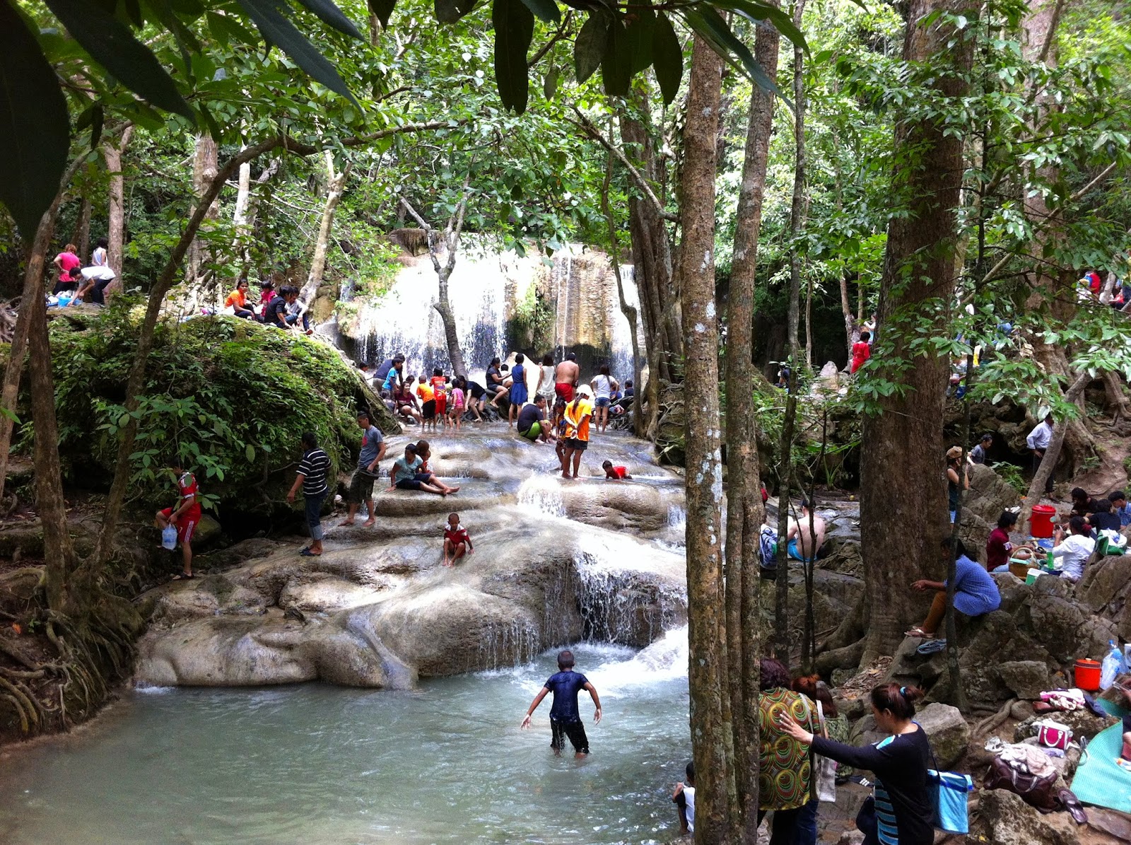
Even on rainy weekends, Kanchanburi is worth a visit. It has been years since my last visit to the 7-tiered Erawan waterfalls and they are now a very busy tourist destination. Locals and foreigners play around in the cool water or lounge on the shores of the stream. The falls are beautiful, but the atmosphere is not quiet and serene. The sheer number of people makes it difficult to get a feeling of "being one with nature."
| Erawan Falls and plenty of visitors |
On the way, I stopped at Pra That Cave. It was is quite a climb to get to the cave entrance. The path was well laid out, but the jungle humidity during rainy season made the climb a sweaty one.
At the cave entrance, a park ranger waited and gave a guided tour once at least four visitors had arrived. Inside the cave were the usual stalactites and stalagmites, but I was surprised by the size of the cave. It is made up of four big rooms and is much bigger than I had expected.
Next on the agenda was the Huay Mae Khamin Waterfalls - the upper tiers could only be reached if you were willing to risk being totally covered in mud as the paths along the stream had turned extremely slippery due to rain. So, I decided to only enjoy the lower tiers and the view of the Sri Nakharin reservoir.
| Beautiful Huay Mae Khamin |
| Two Rainbows Don't Make a Crowd |
As we were crossing, dark clouds came towards us and soon we were drenched. But then, the rain stopped as abrupt as it had started and two rainbows appeared.
Once on the other side, one can drive along the edge of the reservoir - a winding and scenic route - or take another ferry which cuts an hour off the travel time to reach Kanchanaburi city.
Labels:
cave,
Kanchanaburi,
national park,
nature,
waterfall
Friday, August 15, 2014
Uthai Thani - Cyber Waterfall
This waterfall has alternative spellings. I am not sure why "Cyber" seems to be the spelling most frequently used on the Net as it seems very "un-Thai" to me. At the park ranger station, there is a sign offering a much more correct transliteration.
Anyway, the waterfall is located in the Huai Kha Khaeng wildlife sanctuary. One can park near the ranger station and must then trek roughly three kilometers in lush forest before reaching the waterfall.
Sai Bor is actually not an impressive waterfall, but it is a case of "it is not the destination, but the journey" as the trek provides views and sights that make it worthwhile.
More information can be found at:
http://www.huaikhakhaeng.net/
| You can call me Cyber |
Sai Bor is actually not an impressive waterfall, but it is a case of "it is not the destination, but the journey" as the trek provides views and sights that make it worthwhile.
More information can be found at:
http://www.huaikhakhaeng.net/
Labels:
national park,
nature,
Thailand,
travel,
Uthai Thani,
waterfall
Subscribe to:
Posts (Atom)